IMAGES TAKEN NEAR TO
Tanfield Lea Industrial Estate South, STANLEY, DH9 9QX
Introduction
This page details the photographs taken nearby to Tanfield Lea Industrial Estate South, DH9 9QX by members of the Geograph project.
The Geograph project started in 2005 with the aim of publishing, organising and preserving representative images for every square kilometre of Great Britain, Ireland and the Isle of Man.

There are currently over 7.5m images from over14,400 individuals and you can help contribute to the project by visiting https://www.geograph.org.uk
Image Map
Images are licensed for reuse under creativecommons.org/licenses/by-sa/2.0
Notes
- Clicking on the map will re-center to the selected point.
- The higher the marker number, the further away the image location is from the centre of the postcode.
Image Listing (1 Images Found)
Images are licensed for reuse under creativecommons.org/licenses/by-sa/2.0
Image
Details
Distance
1
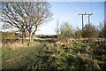
Path and power lines near Tanfield Lea
The path and pylons are crossing ground with scrubby vegetation and scattered trees between two industrial estates at the small County Durham village, Tanfield Lea.
Image: © Trevor Littlewood
Taken: 25 Nov 2021
0.24 miles