IMAGES TAKEN NEAR TO
Tantobie, STANLEY, DH9 9PP
Introduction
This page details the photographs taken nearby to DH9 9PP by members of the Geograph project.
The Geograph project started in 2005 with the aim of publishing, organising and preserving representative images for every square kilometre of Great Britain, Ireland and the Isle of Man.

There are currently over 7.5m images from over14,400 individuals and you can help contribute to the project by visiting https://www.geograph.org.uk
Image Map
Images are licensed for reuse under creativecommons.org/licenses/by-sa/2.0
Notes
- Clicking on the map will re-center to the selected point.
- The higher the marker number, the further away the image location is from the centre of the postcode.
Image Listing (17 Images Found)
Images are licensed for reuse under creativecommons.org/licenses/by-sa/2.0
Image
Details
Distance
1
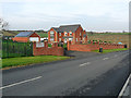
Hedge Row House, Tantobie
Large modern house on the road from Tantobie to Tanfield.
Image: © Oliver Dixon
Taken: 31 Oct 2014
0.03 miles


5
Sleepy Valley, Tantobie
This estate, called Woodside Grove is always known as Sleepy Valley locally. It lies on the western side of the little village of Tantobie, near Stanley.
Image: © Robert Graham
Taken: 11 Jul 2012
0.18 miles
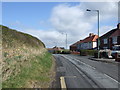
7
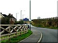
Entering Tantobie (Sleepy Valley) from Tanfield
Image: © Bill Henderson
Taken: 14 Nov 2007
0.18 miles

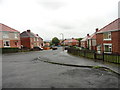
9
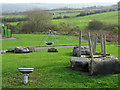
Children's Play area, Woodside Grove
In a small detached estate near Tantobie, locally known as "Sleepy Valley".
Image: © Oliver Dixon
Taken: 31 Oct 2014
0.20 miles
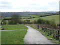
10
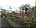
Old wall beside Tanfield Leith Farm
The back lane beside the farm used to be the main road from Tantobie to Stanley until replaced by the B6173 in the later 19th century. The remains of the old roadside wall here and the stone gate posts could well date back to the 18th century.
Image: © Robert Graham
Taken: 6 Mar 2023
0.22 miles