IMAGES TAKEN NEAR TO
Errington Drive, STANLEY, DH9 9PD
Introduction
This page details the photographs taken nearby to Errington Drive, DH9 9PD by members of the Geograph project.
The Geograph project started in 2005 with the aim of publishing, organising and preserving representative images for every square kilometre of Great Britain, Ireland and the Isle of Man.

There are currently over 7.5m images from over14,400 individuals and you can help contribute to the project by visiting https://www.geograph.org.uk
Image Map
Images are licensed for reuse under creativecommons.org/licenses/by-sa/2.0
Notes
- Clicking on the map will re-center to the selected point.
- The higher the marker number, the further away the image location is from the centre of the postcode.
Image Listing (21 Images Found)
Images are licensed for reuse under creativecommons.org/licenses/by-sa/2.0
Image
Details
Distance
1
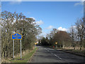
Minor road entering Tanfield Lea
The road enters Tanfield Lea from the south-west passing the blue and yellow road sign which is in a style introduced in County Durham some years ago.
Image: © Trevor Littlewood
Taken: 7 Mar 2014
0.10 miles
2
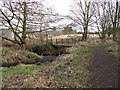
Footbridge in Tanfield Woods
This little footbridge over Kyo Burn leads to the housing estates at Tanfield Lea and is very popular with the local dog walkers.
Image: © Robert Graham
Taken: 9 Mar 2012
0.11 miles
3
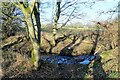
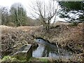
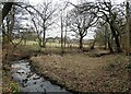
Trees beside the burn
Kyo Burn at the east side of Pea Wood.
Image: © Robert Graham
Taken: 24 Jan 2022
0.12 miles
4
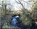
Kyo Burn in Pea Wood
View of the stream which runs through the wood. This is near the east end of the woods, at Tanfield Lea village.
Image: © Robert Graham
Taken: 24 Jan 2022
0.12 miles
5
Woodland burn, Tanfield Lea
The Kyo Burn in Pea Wood in early spring.
Image: © Robert Graham
Taken: 6 Mar 2023
0.13 miles
6
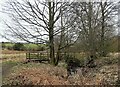
Footbridge over the Kyo Burn
In Pea Wood Nature Reserve at Tanfield Lea.
Image: © Robert Graham
Taken: 24 Jan 2022
0.13 miles
7
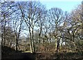
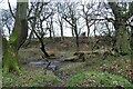
Pea Wood in winter
The woods here go under various names. The present O S map has Pea Wood and Harperley Wood, and Tanfield Woods is also commonly used. I believe Pea Wood is the older name, it was being used 65 years ago to my certain knowledge.
Image: © Robert Graham
Taken: 24 Jan 2022
0.14 miles
8
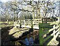
Footbridge over the woodland stream
A wooden footbridge over the Kyo Burn in Pea Wood at Tanfield Lea.
Image: © Robert Graham
Taken: 6 Mar 2023
0.15 miles
9
The Kyo Burn
A stream in Pea Wood at Tanfield Lea. The village can be seen in the background.
Image: © Robert Graham
Taken: 6 Mar 2023
0.16 miles
10
The stream in Harperley Wood
Kyo Burn runs through this wood at near Tanfield Lea. A scene in early spring.
Image: © Robert Graham
Taken: 6 Mar 2023
0.16 miles