IMAGES TAKEN NEAR TO
Parkside, STANLEY, DH9 9NW
Introduction
This page details the photographs taken nearby to Parkside, DH9 9NW by members of the Geograph project.
The Geograph project started in 2005 with the aim of publishing, organising and preserving representative images for every square kilometre of Great Britain, Ireland and the Isle of Man.

There are currently over 7.5m images from over14,400 individuals and you can help contribute to the project by visiting https://www.geograph.org.uk
Image Map
Images are licensed for reuse under creativecommons.org/licenses/by-sa/2.0
Notes
- Clicking on the map will re-center to the selected point.
- The higher the marker number, the further away the image location is from the centre of the postcode.
Image Listing (43 Images Found)
Images are licensed for reuse under creativecommons.org/licenses/by-sa/2.0
Image
Details
Distance
1
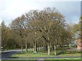
Stand of trees, Tanfield Lea
A detached corner of woodland, at the western end of New Front Street.
Image: © Christine Johnstone
Taken: 13 Apr 2012
0.06 miles
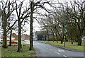
2

Parkside Estate, Tanfield Lea
Tanfield Lea is a former mining village dating mainly from the 19th and early 20th centuries. This estate, on the western side, was built in the 1950's as council housing.
Image: © Robert Graham
Taken: 6 Mar 2023
0.06 miles
3
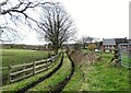
Route of a former railway at Tanfield Lea
This farm track on the west side of Tanfield Lea village is on the route of a former railway line. It was the LNER's Tanfield Branch and operated for coal traffic from the Tanfield Moor Colliery at White-le-Head down to Tanfield and East Tanfield Collieries and on to Gateshead and the River Tyne. This top section was closed in 1947 after the closure of Tanfield Moor Colliery. The line was lifted long ago, but the route remains.
Image: © Robert Graham
Taken: 6 Mar 2023
0.07 miles
4
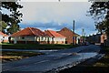
New Front Street, Tanfield Lea
A street in the village of Tanfield Lea.
Image: © Graham Robson
Taken: 28 Oct 2018
0.08 miles
5
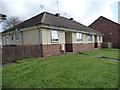
Parkside Cottages
Semi-detached bungalows on New Front Street, Tanfield Lea.
Image: © Christine Johnstone
Taken: 13 Apr 2012
0.08 miles
6

Bus at Tanfield Lea
This is the Stanley Travel service No 713 on its way from Stanley to Tantobie. The service follows a circular route through the local villages taking in Tanfield Lea, Tantobie, Flint Hill, Dipton and Annfield Plain among others.
Image: © Robert Graham
Taken: 6 Mar 2023
0.08 miles
7
New Front Street, Tanfield Lea
A bit of a misnomer, as this was the original Front Street in the 19th century. It seems to have been renamed in the post war period after a re-alinement of the roads. The village shops etc were all along here, and still are.
Image: © Robert Graham
Taken: 6 Mar 2023
0.08 miles
8
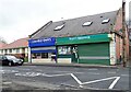
Village shops in Tanfield Lea
Local shops on new Front Street, the village centre. Tanfield Lea is a former mining village, mostly dating from the 19th century.
Image: © Robert Graham
Taken: 6 Mar 2023
0.08 miles
9
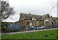
Tanfield Lea Primary School
This was originally built in 1893 as The Tanfield Board School.
Image: © Robert Graham
Taken: 6 Mar 2023
0.09 miles
10
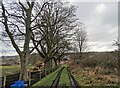
Trackside trees at Tanfield Lea
Winter trees alongside the farm track from Tanfield Leith to the village of Tanfield Lea. The estate ahead is Parkside, built in the 1950's as council housing.
Image: © Robert Graham
Taken: 6 Mar 2023
0.09 miles