IMAGES TAKEN NEAR TO
Ivanhoe Terrace, STANLEY, DH9 9HT
Introduction
This page details the photographs taken nearby to Ivanhoe Terrace, DH9 9HT by members of the Geograph project.
The Geograph project started in 2005 with the aim of publishing, organising and preserving representative images for every square kilometre of Great Britain, Ireland and the Isle of Man.

There are currently over 7.5m images from over14,400 individuals and you can help contribute to the project by visiting https://www.geograph.org.uk
Image Map (Loading...)


Getting Data...Please wait
Leaflet Map data © OpenStreetMap
Images are licensed for reuse under creativecommons.org/licenses/by-sa/2.0
Notes
- Clicking on the map will re-center to the selected point.
- The higher the marker number, the further away the image location is from the centre of the postcode.
Image Listing (27 Images Found)
Images are licensed for reuse under creativecommons.org/licenses/by-sa/2.0
Image
Details
Distance
1
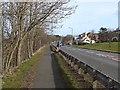
Front Street, Dipton
The footway along the busy A692 has been designated for shared use by pedestrians and cyclists.
Image: © Oliver Dixon
Taken: 28 Feb 2014
0.07 miles
2
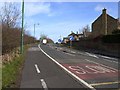
Main road between Dipton and Burnopfield
A cycle track has been established on the footway beside the busy A692 main road from Consett to Gateshead.
Image: © Oliver Dixon
Taken: 28 Feb 2014
0.12 miles
3
Italian restaurant, Dipton
On Front Street, Hilltop. This used to be a pub and has been put to a good use, many village pubs have been demolished or converted to private dwellings. I think it used to be The Grey Horse.
Image: © Robert Graham
Taken: 6 Jun 2014
0.13 miles
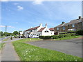
4
Houses on Front Street, Dipton
Much of the former colliery village of Dipton dates back to the late 19th and early 20th centuries, as these houses probably do.
Image: © Robert Graham
Taken: 3 Aug 2020
0.14 miles
5
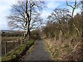
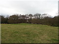
Footpath from Flint Hill to Dipton
It seems very possible that this footpath follows the track of an old mineral railway.
Image: © Oliver Dixon
Taken: 28 Feb 2014
0.15 miles
6
Wild flowers on a vacant plot at Dipton
A little plot beside Front Street in Dipton. There used to be some old cottages here, and later it was an allotment garden, but is now unused. The flowers are weeds to some, and wild flowers to others.
Image: © Robert Graham
Taken: 3 Aug 2020
0.16 miles
7
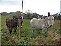
Donkeys at Dipton
A couple of donkeys in shaggy winter coats at Colliery Lane, just off Front Street in the village.
Image: © Robert Graham
Taken: 20 Mar 2019
0.17 miles
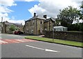
8
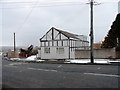
Former Co-op store
This building on Flint Hill Bank at Dipton used to be the local Co-op grocery store. Now it's a private dwelling.
Image: © Robert Graham
Taken: 27 Mar 2013
0.17 miles
9
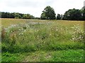
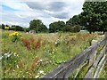
Wild flower plot at Dipton
This is beside Front Street, towards the northern end of the village. I think this was once the site of the gas works. These wild flower meadows are becoming quite popular in this area of County Durham, and have a lot to recommend them. Once created, they only need cutting and raking once a year, and should be self seeding. Much nicer than sterile mowed grass.
Image: © Robert Graham
Taken: 3 Aug 2020
0.18 miles
10
Fallen tree beside the path
The path in question being the old Western Way waggonway used in the eighteenth century to carry coals from the pits in the Dipton area to the staithes on the Tyne. It is now the footpath known locally as The Bottoms.
Image: © Robert Graham
Taken: 9 Mar 2012
0.18 miles