IMAGES TAKEN NEAR TO
Dunns Buildings, STANLEY, DH9 8TE
Introduction
This page details the photographs taken nearby to Dunns Buildings, DH9 8TE by members of the Geograph project.
The Geograph project started in 2005 with the aim of publishing, organising and preserving representative images for every square kilometre of Great Britain, Ireland and the Isle of Man.

There are currently over 7.5m images from over14,400 individuals and you can help contribute to the project by visiting https://www.geograph.org.uk
Image Map
Images are licensed for reuse under creativecommons.org/licenses/by-sa/2.0
Notes
- Clicking on the map will re-center to the selected point.
- The higher the marker number, the further away the image location is from the centre of the postcode.
Image Listing (3 Images Found)
Images are licensed for reuse under creativecommons.org/licenses/by-sa/2.0
Image
Details
Distance
1
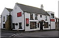
"Ye Old Earl Grey Inn", West Kyo, Co. Durham
The word “kyo” means cows. John Buddle, the famous mining engineer, was born at Kyo in 1774, and later went on to work with the Marquis of Londonderry in the development of Seaham Harbour.
Image: © Alan Fearon
Taken: 10 Nov 2005
0.08 miles
2
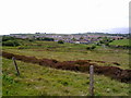
View across the bogs
Looking across Kyo Bogs to Annfield Plain and Catchgate. Pontop Pike on the horizon.
Image: © Robert Graham
Taken: 1 Jun 2011
0.08 miles
3
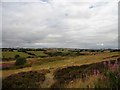
Heathland at Kyo Bogs
There is not much lowland heath surviving in County Durham, and this is one of the few areas left. The view is looking north from the railway path over Riding Hills Farm to Tantobie village beyond.
Image: © Robert Graham
Taken: 24 Jul 2018
0.24 miles