IMAGES TAKEN NEAR TO
Wesley Court, STANLEY, DH9 8QA
Introduction
This page details the photographs taken nearby to Wesley Court, DH9 8QA by members of the Geograph project.
The Geograph project started in 2005 with the aim of publishing, organising and preserving representative images for every square kilometre of Great Britain, Ireland and the Isle of Man.

There are currently over 7.5m images from over14,400 individuals and you can help contribute to the project by visiting https://www.geograph.org.uk
Image Map
Images are licensed for reuse under creativecommons.org/licenses/by-sa/2.0
Notes
- Clicking on the map will re-center to the selected point.
- The higher the marker number, the further away the image location is from the centre of the postcode.
Image Listing (11 Images Found)
Images are licensed for reuse under creativecommons.org/licenses/by-sa/2.0
Image
Details
Distance
1
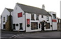
"Ye Old Earl Grey Inn", West Kyo, Co. Durham
The word “kyo” means cows. John Buddle, the famous mining engineer, was born at Kyo in 1774, and later went on to work with the Marquis of Londonderry in the development of Seaham Harbour.
Image: © Alan Fearon
Taken: 10 Nov 2005
0.13 miles
2
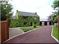
Fines House, Annfield Plain
This old farmhouse has a long history. According to local historian Fred Wade, there was a farm here from at least 1755, when it was first mentioned. I would imagine that this house isn't quite that old, early C19 perhaps. It is now residential only, no longer a working farm.
Image: © Robert Graham
Taken: 11 Jun 2014
0.14 miles
3
Funeral Parlour at Fines House
This business occupies part of the former farm here at Annfield Plain. Note the old milk churns round the back at the left, for decorative effect I assume.
Image: © Robert Graham
Taken: 11 Jun 2014
0.14 miles
4
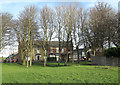
Grassed area in Annfield Plain
The houses are on the east side of the B6168 in Annfield Plain; the grass is on the west side.
Image: © Trevor Littlewood
Taken: 16 Dec 2013
0.14 miles
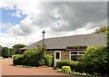
5
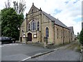
Catchgate Methodist Church
On North Road, at the south end of the village.
Image: © Robert Graham
Taken: 11 Jun 2014
0.16 miles
6
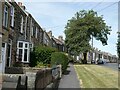
Queen's Parade
Terraced houses facing on to New Front Street (B6168).
Image: © Oliver Dixon
Taken: 11 Jul 2022
0.16 miles
7
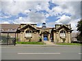
Annfield Plain Library
This fine old building is on North Road. Dates from 1908 and still in use.
Image: © Robert Graham
Taken: 11 Jun 2014
0.18 miles
8
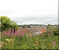
View over Stanhope Gardens from the railway
Looking from the railway walk over this council housing estate at Annfield Plain. The view takes in Pontop Pike in the distance.
Image: © Robert Graham
Taken: 24 Jul 2018
0.18 miles
9

Annfield Plain Public Library
Durham's only Carnegie Library, this handsome building was erected in 1908.
Image: © Alan Fearon
Taken: 10 Nov 2005
0.20 miles
10
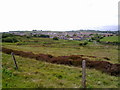
View across the bogs
Looking across Kyo Bogs to Annfield Plain and Catchgate. Pontop Pike on the horizon.
Image: © Robert Graham
Taken: 1 Jun 2011
0.21 miles