IMAGES TAKEN NEAR TO
Annfield Place, STANLEY, DH9 8NP
Introduction
This page details the photographs taken nearby to Annfield Place, DH9 8NP by members of the Geograph project.
The Geograph project started in 2005 with the aim of publishing, organising and preserving representative images for every square kilometre of Great Britain, Ireland and the Isle of Man.

There are currently over 7.5m images from over14,400 individuals and you can help contribute to the project by visiting https://www.geograph.org.uk
Image Map
Images are licensed for reuse under creativecommons.org/licenses/by-sa/2.0
Notes
- Clicking on the map will re-center to the selected point.
- The higher the marker number, the further away the image location is from the centre of the postcode.
Image Listing (6 Images Found)
Images are licensed for reuse under creativecommons.org/licenses/by-sa/2.0
Image
Details
Distance
1
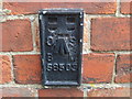
Ordnance Survey Flush Bracket S8503
This bracket can be found on the wall of the Community Centre.
For more detail see : http://www.bench-marks.org.uk/bm21225
Image: © Peter Wood
Taken: 18 May 2012
0.11 miles
2
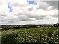
View from Loud Hill, Annfield Plain
View looking south east. Loud Hill, to the west of the village, gives fine views over the countryside.
Image: © Robert Graham
Taken: 11 Jun 2014
0.12 miles
3

Looking across to Loud Hill
Looking north from the side of the main road at Greencroft. There is a new housing estate being built opposite Loud Terrace.
Image: © Robert Graham
Taken: 20 Jul 2020
0.14 miles
4
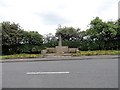
War memorial on Loud Hill
This commemorates the death of a WW1 airman in an air crash in 1918. It would have been a very unusual event at the time in this area.
Image: © Robert Graham
Taken: 11 Jun 2014
0.18 miles
5
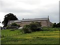
Outbuildings at Annfield House
This farm seems to have been converted to residential accommodation in recent times. The building on the right was once probably a courtyard type range of farm buildings, a typical C19 set up for large farms.
Image: © Robert Graham
Taken: 11 Jun 2014
0.24 miles
6
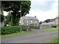
Annfield House
This former farmhouse has been here since 1778, before the village of Annfleld Plain came into existence. Although modified, it still has the typical look of an C18 farmhouse, if a rather grand one. It sits in a prominent position on the top of Loud Hill, above the present day village.
Image: © Robert Graham
Taken: 11 Jun 2014
0.24 miles