IMAGES TAKEN NEAR TO
Parkhead, STANLEY, DH9 7YB
Introduction
This page details the photographs taken nearby to Parkhead, DH9 7YB by members of the Geograph project.
The Geograph project started in 2005 with the aim of publishing, organising and preserving representative images for every square kilometre of Great Britain, Ireland and the Isle of Man.

There are currently over 7.5m images from over14,400 individuals and you can help contribute to the project by visiting https://www.geograph.org.uk
Image Map
Images are licensed for reuse under creativecommons.org/licenses/by-sa/2.0
Notes
- Clicking on the map will re-center to the selected point.
- The higher the marker number, the further away the image location is from the centre of the postcode.
Image Listing (13 Images Found)
Images are licensed for reuse under creativecommons.org/licenses/by-sa/2.0
Image
Details
Distance
1
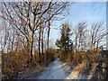
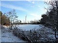
Snow covered path
A path through the little strip of woodland between the Annfield Plain bypass and the nearby Industrial Estate.
Image: © Robert Graham
Taken: 12 Dec 2017
0.11 miles
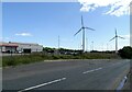
2
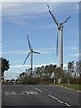
Wind turbines in the Greencroft Industrial Estate
Seen from Tower Road.
Image: © Oliver Dixon
Taken: 25 Oct 2018
0.13 miles
3
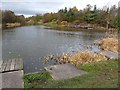
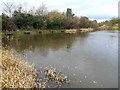
Greencroft Pond
Fishing lake in the Greencroft Industrial Estate. The lake occupies a World War 2 bomb crater. A near miss on the ball-bearing factory close by.
Image: © Oliver Dixon
Taken: 13 Nov 2012
0.15 miles
4
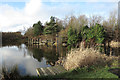
Pool west of Greencroft Parkway
The pool lies at the centre of the Greencroft Industrial Park near to Annfield Plain in County Durham. The pool is used presumably for fishing; the boarding in the foreground is surely a fisherman's stance and OS maps show a fish symbol beside the water.
Image: © Trevor Littlewood
Taken: 16 Dec 2013
0.15 miles
5
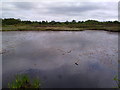
No fishing today
This is a fishing pond at Greencroft Industrial Estate, covered with ice on a snowy December morning.
Image: © Robert Graham
Taken: 12 Dec 2017
0.15 miles
6
Greencroft Pond
Fishing lake in the Greencroft Industrial Estate, showing fishing stages. The lake occupies a World War 2 bomb crater. A near miss on the ball-bearing factory close by.
Image: © Oliver Dixon
Taken: 13 Nov 2012
0.16 miles
7
Pond on Greencroft Heath
Small pond on the heath - Bog Cotton on the farside.
Image: © Robert Graham
Taken: 1 Jun 2011
0.19 miles
8
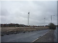
Development land and wind turbines
Off Tower Road.
Image: © JThomas
Taken: 2 Apr 2016
0.19 miles
9

Wind turbines at Greencroft
On the industrial estate. Viewed from Tower Road.
Image: © Robert Graham
Taken: 16 Jul 2021
0.21 miles
10
Greencroft Industrial Estate
Viewed from Tower Road, on the south side. The ball bearing factory of Ransome and Marles originally occupied this site. They built a large factory here in 1954 which employed 2000 people in its heyday, but closed in 1982. I think this was the site of the main entrance, hence the layby beside the road.
Image: © Robert Graham
Taken: 16 Jul 2021
0.21 miles