IMAGES TAKEN NEAR TO
Bracken Close, STANLEY, DH9 7RR
Introduction
This page details the photographs taken nearby to Bracken Close, DH9 7RR by members of the Geograph project.
The Geograph project started in 2005 with the aim of publishing, organising and preserving representative images for every square kilometre of Great Britain, Ireland and the Isle of Man.

There are currently over 7.5m images from over14,400 individuals and you can help contribute to the project by visiting https://www.geograph.org.uk
Image Map
Images are licensed for reuse under creativecommons.org/licenses/by-sa/2.0
Notes
- Clicking on the map will re-center to the selected point.
- The higher the marker number, the further away the image location is from the centre of the postcode.
Image Listing (33 Images Found)
Images are licensed for reuse under creativecommons.org/licenses/by-sa/2.0
Image
Details
Distance
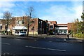
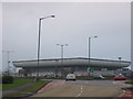
1
"Iceland", Stanley
Part of a modern development to the north of Stanley town centre.
Image: © Oliver Dixon
Taken: 8 Jan 2014
0.11 miles
2
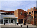
The Louisa Centre, Stanley
Council owned sports and leisure centre
Image: © John Chamberlain
Taken: 23 Mar 2006
0.12 miles
3
Stanley Civic Hall and The Louisa Centre
Stanley's civic hall and adjacent leisure centre are located on Front Street in the centre of the town.
Image: © Graham Robson
Taken: 28 Oct 2018
0.14 miles
4
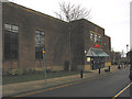
LampLight Arts Centre, Stanley
A sixties building refurbished in 1991. Currently displaying wonderful landscapes in watercolours by local artist George Hutchinson.
Image: © Pauline E
Taken: 29 Dec 2007
0.14 miles
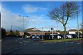
5
Asda
View of one of the large prominent buildings when travelling through Stanley.
Image: © Colin Edgar
Taken: 15 Jan 2006
0.14 miles
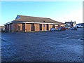
6
Iceland Supermarket, Scott Street, Stanley
A large car park with a building housing a branch of the Iceland supermarket chain at its rear.
Image: © Graham Robson
Taken: 28 Oct 2018
0.15 miles
7
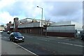
Supermarket and bowls centre, Stanley
An ASDA supermarket occupies the ground floor of this large building, and an indoor bowls centre occupies the upper floor.
Image: © Graham Robson
Taken: 28 Oct 2018
0.15 miles
8
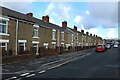
Louisa Terrace, Stanley
A long row of terraced houses close to Stanley town centre.
Image: © Graham Robson
Taken: 28 Oct 2018
0.15 miles
9
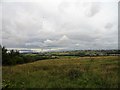
View from behind Front Street in Stanley
Stanley occupies a hilltop site which gives extensive views over the surrounding countryside. This position just north of the main street gives a good view to the north and west. On the left here is Pontop Pike with its TV mast and Flint Hill and White le head on the hill top on the right.
Image: © Robert Graham
Taken: 17 Aug 2018
0.15 miles
10
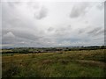
Countryside view from Stanley
This viewpoint is just behind Front Street, on the north side. The towns hilltop position gives a good vantage point. In the distance can be seen the old mining villages of Tanfield Lea, and Tantobie and White le Head on the hilltop.
Image: © Robert Graham
Taken: 17 Aug 2018
0.16 miles