IMAGES TAKEN NEAR TO
Gray Terrace, STANLEY, DH9 7LB
Introduction
This page details the photographs taken nearby to Gray Terrace, DH9 7LB by members of the Geograph project.
The Geograph project started in 2005 with the aim of publishing, organising and preserving representative images for every square kilometre of Great Britain, Ireland and the Isle of Man.

There are currently over 7.5m images from over14,400 individuals and you can help contribute to the project by visiting https://www.geograph.org.uk
Image Map
Images are licensed for reuse under creativecommons.org/licenses/by-sa/2.0
Notes
- Clicking on the map will re-center to the selected point.
- The higher the marker number, the further away the image location is from the centre of the postcode.
Image Listing (16 Images Found)
Images are licensed for reuse under creativecommons.org/licenses/by-sa/2.0
Image
Details
Distance
1
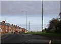
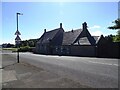
Shieldrow Lane, New Kyo
The terraced houses are Gray Terrace, Edwardian in date, from the early 1900's.
Image: © Robert Graham
Taken: 23 Oct 2023
0.03 miles
2
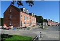
New houses nearing completion at New Kyo
These are on the site of the former Sandhole Working Men's Club.
Image: © Robert Graham
Taken: 16 Jul 2021
0.08 miles
3
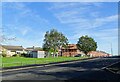
Building site at New Kyo
A small terrace of houses being constructed on Shield Row Lane, the main road through the village. This is on the site of the former Sandhole Working Men's Club, which was recently demolished. Many local clubs have closed in recent years, along with village pubs.
Image: © Robert Graham
Taken: 29 Sep 2020
0.09 miles
4
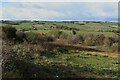
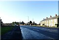
Grass fields off Kyo Lane
Undulating grassland off Kyo Lane on the edge of Stanley.
Image: © Graham Robson
Taken: 28 Oct 2018
0.18 miles
5
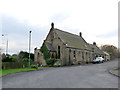
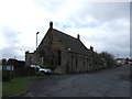
Converted chapel on Shieldrow Lane
A Primitive Methodist Chapel, converted to a private house. For a while, operated as a bed and breakfast establishment.
Image: © Oliver Dixon
Taken: 31 Oct 2014
0.18 miles
6
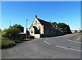
Former chapel at Oxhill
This is the former Oxhill Methodist Chapel , opened in 1877 (inscription on the gable). Closed around 1977 and sold off and converted to a private dwelling. Stands on Shieldrow Lane.
Image: © Robert Graham
Taken: 8 Jul 2024
0.18 miles
8
Former chapel from the west
Looking along Shieldrow Lane to Oxhill. The Methodist chapel opened in 1874 and closed about 1977. It was then sold off and converted to a private house.
Image: © Robert Graham
Taken: 8 Jul 2024
0.18 miles
10
Start of the Annfield Plain by-pass
The by-pass on the A693 starts here at Oxhill, on the left here. The original road can be seen in the centre, to the right of the former Methodist Chapel. Lintz Terrace is on the right. Originally, this was the site of a level crossing for the colliery line to the Louisa pit at Stanley.
Image: © Robert Graham
Taken: 24 Jan 2022
0.20 miles