IMAGES TAKEN NEAR TO
Ballater Close, STANLEY, DH9 6UN
Introduction
This page details the photographs taken nearby to Ballater Close, DH9 6UN by members of the Geograph project.
The Geograph project started in 2005 with the aim of publishing, organising and preserving representative images for every square kilometre of Great Britain, Ireland and the Isle of Man.

There are currently over 7.5m images from over14,400 individuals and you can help contribute to the project by visiting https://www.geograph.org.uk
Image Map
Images are licensed for reuse under creativecommons.org/licenses/by-sa/2.0
Notes
- Clicking on the map will re-center to the selected point.
- The higher the marker number, the further away the image location is from the centre of the postcode.
Image Listing (6 Images Found)
Images are licensed for reuse under creativecommons.org/licenses/by-sa/2.0
Image
Details
Distance

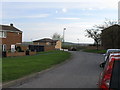
2
View across the path to Low Stanley
Looking north to the housing estate at East Stanley
Image: © Robert Graham
Taken: 16 Sep 2019
0.18 miles

5
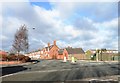
East Street, Stanley
This road leads off the main A693 in East Stanley down the bank to Shield Row and the main Newcastle road.
Image: © Robert Graham
Taken: 6 Feb 2013
0.21 miles