IMAGES TAKEN NEAR TO
Keir Hardie Avenue, STANLEY, DH9 6LE
Introduction
This page details the photographs taken nearby to Keir Hardie Avenue, DH9 6LE by members of the Geograph project.
The Geograph project started in 2005 with the aim of publishing, organising and preserving representative images for every square kilometre of Great Britain, Ireland and the Isle of Man.

There are currently over 7.5m images from over14,400 individuals and you can help contribute to the project by visiting https://www.geograph.org.uk
Image Map
Images are licensed for reuse under creativecommons.org/licenses/by-sa/2.0
Notes
- Clicking on the map will re-center to the selected point.
- The higher the marker number, the further away the image location is from the centre of the postcode.
Image Listing (13 Images Found)
Images are licensed for reuse under creativecommons.org/licenses/by-sa/2.0
Image
Details
Distance
1
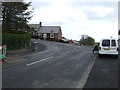
Junction of Tyne Road East with South Street
Image: © JThomas
Taken: 31 Mar 2012
0.06 miles
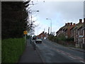
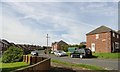
4
View up Tyne Road
This is the main route through South Stanley on the west side. Tyne Road is viewed here from the junction with Holly Hill Gardens West, looking north as the road goes up to Stanley town centre on the hilltop.
Image: © Robert Graham
Taken: 12 Aug 2019
0.12 miles
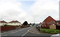
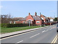
6
Road junction at Holly Hill Gardens
Junction of the East and West sections. This part of the large South Stanley estate was built in the early 1950's as part of the large programme of council house building undertaken post war. These were excellent houses at the time, and still are.
Image: © Robert Graham
Taken: 12 Aug 2019
0.20 miles
7
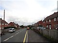
Holly Hill Gardens West
A typical street in this southern part of South Stanley, which was built as council housing in the 1950's. The buses run along this street, as can be seen from the stop on the left.
Image: © Robert Graham
Taken: 12 Aug 2019
0.20 miles
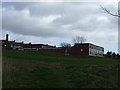
8
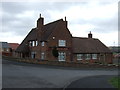
St Mary's Roman Catholic School, South Stanley
Image: © Peter Gregson
Taken: 7 Apr 2007
0.21 miles
9
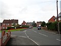
Road junction at South Stanley
This is the eastern end of Wansbeck Avenue at its junction with Wear Road. This is at the top end of the suburb of South Stanley, a large area of housing estates next to Stanley town centre.
Image: © Robert Graham
Taken: 13 Sep 2019
0.22 miles
10
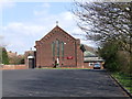
St Mary's Roman Catholic Church, South Stanley
Image: © Peter Gregson
Taken: 7 Apr 2007
0.23 miles