IMAGES TAKEN NEAR TO
Craghead, STANLEY, DH9 6EX
Introduction
This page details the photographs taken nearby to DH9 6EX by members of the Geograph project.
The Geograph project started in 2005 with the aim of publishing, organising and preserving representative images for every square kilometre of Great Britain, Ireland and the Isle of Man.

There are currently over 7.5m images from over14,400 individuals and you can help contribute to the project by visiting https://www.geograph.org.uk
Image Map
Images are licensed for reuse under creativecommons.org/licenses/by-sa/2.0
Notes
- Clicking on the map will re-center to the selected point.
- The higher the marker number, the further away the image location is from the centre of the postcode.
Image Listing (20 Images Found)
Images are licensed for reuse under creativecommons.org/licenses/by-sa/2.0
Image
Details
Distance
1
Looking east down Wagtail Lane, Craghead
The houses are Ousterley Terrace, at the western end of the village.
Image: © Robert Graham
Taken: 30 May 2014
0.08 miles
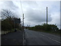
3
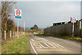
Wagtail Lane entering Craghead
The first terraced houses of Craghead are just around the bend in the road, hence the multiple warnings of speed limit and the need to reduce speed. The sign naming Craghead is in the typical County Durham style of yellow lettering on blue background.
Image: © Trevor Littlewood
Taken: 15 Feb 2017
0.13 miles
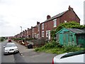
5
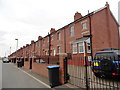
Wylam Street, Craghead
This old terraced street has been revitalised in recent years.
Image: © Robert Graham
Taken: 30 May 2014
0.15 miles
8
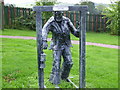
Sculpture of miner Craghead near Stanley
Image: © P Glenwright
Taken: 23 Sep 2006
0.17 miles