IMAGES TAKEN NEAR TO
Chester Road, STANLEY, DH9 0TJ
Introduction
This page details the photographs taken nearby to Chester Road, DH9 0TJ by members of the Geograph project.
The Geograph project started in 2005 with the aim of publishing, organising and preserving representative images for every square kilometre of Great Britain, Ireland and the Isle of Man.

There are currently over 7.5m images from over14,400 individuals and you can help contribute to the project by visiting https://www.geograph.org.uk
Image Map
Images are licensed for reuse under creativecommons.org/licenses/by-sa/2.0
Notes
- Clicking on the map will re-center to the selected point.
- The higher the marker number, the further away the image location is from the centre of the postcode.
Image Listing (20 Images Found)
Images are licensed for reuse under creativecommons.org/licenses/by-sa/2.0
Image
Details
Distance
1
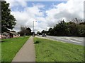
A693 at East Stanley
This is the main road out of Stanley town to the east, leading to Chester Le Street and the A1M motorway.
Image: © Robert Graham
Taken: 13 Jul 2012
0.03 miles
2
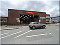
Bus depot at East Stanley
This is the local depot for Go North East's buses in the Stanley and Consett areas. Known locally as the Northern Garage, because it was owned by the Northern Bus Company for many years.
Image: © Robert Graham
Taken: 13 Jul 2012
0.06 miles
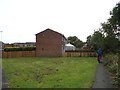
3
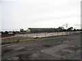
Site of the former bus depot in Stanley
Go Northeast moved its bus depot for NW Durham to a new one in Consett in Feb 2019. The Stanley depot, on Chester Road had been built in the 1920's. Demolition and clearing of the site has been swift, and was completed in July.
Image: © Robert Graham
Taken: 13 Sep 2019
0.07 miles
4
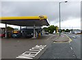
Jet Filling Station
High Street, Stanley.
Image: © Russel Wills
Taken: 4 Sep 2016
0.09 miles
5
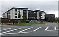
North Durham Academy
High Street, Stanley.
Image: © Russel Wills
Taken: 4 Sep 2016
0.12 miles
6
Footpath at Arnold Close, East Stanley
The path here long predates the modern housing estate. It is shown on 19th century maps leading to the old farm of Stanley Hall, which used to be a manor house in the middle ages. It was demolished in the 1930's.
Image: © Robert Graham
Taken: 13 Sep 2019
0.13 miles
7
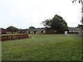
Chaucer Close, East Stanley
This is part of a large estate built at East Stanley by the council in the 1960's I think. All the streets are named after British poets and writers.
Image: © Robert Graham
Taken: 13 Sep 2019
0.14 miles
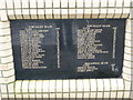
8
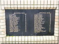
West Stanley Pit Memorial, Stanley, Co. Durham
Inscriptions on first panel of the memorial.
Image: © Philip Soakell
Taken: 24 Feb 2011
0.17 miles
9
West Stanley Pit Memorial, Stanley, Co. Durham
Inscriptions on second panel of memorial.
Image: © Philip Soakell
Taken: 24 Feb 2011
0.17 miles
10
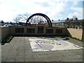
West Stanley Pit Memorial, Stanley, Co. Durham
Taken on 23rd March 2011, whilst the site investigation works were in progress for the construction of North Durham Academy at Stanley.
Image: © Philip Soakell
Taken: 23 Mar 2011
0.17 miles