
IMAGES TAKEN NEAR TO
Beamish, STANLEY, DH9 0SW
Introduction
This page details the photographs taken nearby to DH9 0SW by members of the Geograph project.
The Geograph project started in 2005 with the aim of publishing, organising and preserving representative images for every square kilometre of Great Britain, Ireland and the Isle of Man.

There are currently over 7.5m images from over14,400 individuals and you can help contribute to the project by visiting https://www.geograph.org.uk
Image Map
Images are licensed for reuse under creativecommons.org/licenses/by-sa/2.0
Notes
- Clicking on the map will re-center to the selected point.
- The higher the marker number, the further away the image location is from the centre of the postcode.
Image Listing (15 Images Found)
Images are licensed for reuse under creativecommons.org/licenses/by-sa/2.0
Image
Details
Distance
1
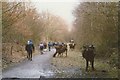
Cattle sculptures on disused rail line near Beamish
Image: © Peter Robinson
Taken: 12 Jan 1997
0.08 miles

4

Cyclist and horse riders at Beamish - and some unexpected livestock
On the Consett and Sunderland railway path, part of the famous C2C cycle route. Built by Sally Matthews, the Beamish Shorthorns, constructed from scrap metal contentedly graze by the side of the track.
Image: © Oliver Dixon
Taken: 8 Jan 2014
0.10 miles
5
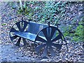
Memorial seat on the Consett and Sunderland railway path
In memory of Tommy Thompson 1939-2007.
Image: © Oliver Dixon
Taken: 8 Jan 2014
0.11 miles
6
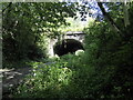
Beamish East Tunnel
The west portal of Beamish No. 1 or East Tunnel (Bridge No. 14) which carries Station Road over the Consett and Sunderland Railway Path and formerly carried a colliery waggonway. Immediately beyond the tunnel is the site of Beamish Station.
Image: © Adrian Taylor
Taken: 20 Aug 2020
0.13 miles
7
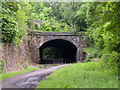
Eastern portal of old railway tunnel at Beamish
The old rail route through Beamish in County Durham now has the responsibility of carrying three named paths and cycle routes: the 'C2C Cycle Route', the 'Great North Forest Heritage Trail' and the 'Consett and Sunderland Railway Path'.
The tunnel seen here is one of two that follow in close succession neither of which cuts through particularly high ground; it's surprising that the route was tunnelled rather than cuttings being made.
Image: © Trevor Littlewood
Taken: 26 Jun 2012
0.14 miles
8

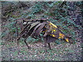
One of the Beamish shorthorns
Built by Sally Matthews, the Beamish Shorthorns, constructed from scrap metal contentedly graze by the side of the Consett and Sunderland railway path (part of the C2C cycle route). www.sustrans.org.uk/default.asp?sID=1121269805734
Image: © Oliver Dixon
Taken: 7 Jun 2003
0.18 miles
9
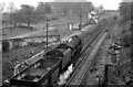
Site of Beamish Station
View eastwards, towards Tyne Dock (via Pelaw) and Newcastle (via Birtley), former Stanhope & Tyne (Pontop & South Shields) Railway. Beamish station was closed to passengers 21/9/53 (goods, 2/8/60); the passenger service Blackhill - Birtley - Newcastle ceased 23/5/55. The photograph shows a BR 9F 2-10-0 returning down the steep incline through Beamish on iron-ore empties returning from Consett to Tyne Dock, a traffic that continued until 1974.
Image: © Ben Brooksbank
Taken: 10 May 1965
0.20 miles
10
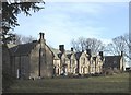
Methold Houses, Beamish
Social Housing visible from the Shepherd & Shepherdess Pub. Erected c.1863 for John Eden the owner of the Beamish Estates at the time. Local folklore has it that the plan of the development is in the shape of an 'E' for his surname. Sandstone used extensively in construction.
Image: © John Bedlington
Taken: Unknown
0.21 miles