IMAGES TAKEN NEAR TO
STANLEY, DH9 0SH
Introduction
This page details the photographs taken nearby to DH9 0SH by members of the Geograph project.
The Geograph project started in 2005 with the aim of publishing, organising and preserving representative images for every square kilometre of Great Britain, Ireland and the Isle of Man.

There are currently over 7.5m images from over14,400 individuals and you can help contribute to the project by visiting https://www.geograph.org.uk
Image Map
Images are licensed for reuse under creativecommons.org/licenses/by-sa/2.0
Notes
- Clicking on the map will re-center to the selected point.
- The higher the marker number, the further away the image location is from the centre of the postcode.
Image Listing (11 Images Found)
Images are licensed for reuse under creativecommons.org/licenses/by-sa/2.0
Image
Details
Distance
1
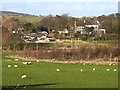
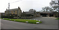
Urpeth South Farm
Seen from the Consett and Sunderland Railway Path.
Image: © Oliver Dixon
Taken: 8 Jan 2014
0.02 miles
2
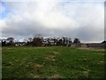
Urpeth South Farm
This farm stands to the west of Pelton. Urpeth Hall is just behind the farm buildings.
Image: © Robert Graham
Taken: 6 Feb 2013
0.02 miles
3
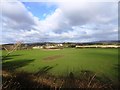
View of Urpeth Hall
Looking north from the old railway path west of Pelton. The hall was the home of the late Sir Bobby Robson.
Image: © Robert Graham
Taken: 6 Feb 2013
0.04 miles
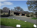
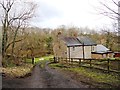
4
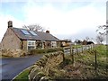
Keepers Cottage at Urpeth Hall
This stands beside the minor road between the villages of High Handenhold and High Urpeth, to the west of Pelton.
Image: © Robert Graham
Taken: 6 Feb 2013
0.07 miles
6
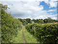
Footpath near High Urpeth
High Urpeth is a small settlement in the north of County Durham.
Image: © Trevor Littlewood
Taken: 4 Aug 2015
0.13 miles
8
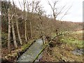
Beamish Burn at Urpeth Forge
Looking west along the burn from the road. The burn was the reason for all the industry down here in the 18th and 19th centuries.
Image: © Robert Graham
Taken: 6 Feb 2013
0.23 miles
9
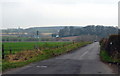
The road to High Urpeth
Taken from the entrance to an old tip near Urpeth. High Urpeth is mostly hidden by the trees in the distance. The area to the left of the picture is called 'Mire Dubs' on the map. What on earth does this mean?
Image: © Alan Fearon
Taken: 6 Feb 2006
0.24 miles
10
Urpeth Forge
One of the remaining buildings of what used to be a busy industrial area in the 18th and 19th centuries.
Image: © Robert Graham
Taken: 6 Feb 2013
0.24 miles