IMAGES TAKEN NEAR TO
Station Road, STANLEY, DH9 0QU
Introduction
This page details the photographs taken nearby to Station Road, DH9 0QU by members of the Geograph project.
The Geograph project started in 2005 with the aim of publishing, organising and preserving representative images for every square kilometre of Great Britain, Ireland and the Isle of Man.

There are currently over 7.5m images from over14,400 individuals and you can help contribute to the project by visiting https://www.geograph.org.uk
Image Map
Images are licensed for reuse under creativecommons.org/licenses/by-sa/2.0
Notes
- Clicking on the map will re-center to the selected point.
- The higher the marker number, the further away the image location is from the centre of the postcode.
Image Listing (10 Images Found)
Images are licensed for reuse under creativecommons.org/licenses/by-sa/2.0
Image
Details
Distance
1
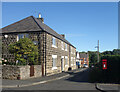
Peggy's Wicket, Beamish
A side street in Beamish village with an unusual name.
Image: © Des Blenkinsopp
Taken: 26 Aug 2022
0.02 miles
2
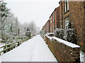
Peggy's Wicket
Old houses in Beamish known as Peggy's Wicket. Overlooking the old Consett railway line (now the C2C long distance cycle path). The gardens to the left are on the railway embankment. The C2C is about 15m to the north and 10m lower than this footpath, running parallel to it. Photograph taken from the footbridge over the C2C (takes you into Beamish Woods).
Image: © John Bedlington
Taken: 12 Feb 2009
0.07 miles
3
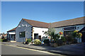
Indian or Italian?
A choice of cuisines side by side.
Ala Spicery and Il Cancello restaurants along New Road.
Image: © Des Blenkinsopp
Taken: 26 Aug 2022
0.13 miles
4
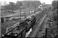
Site of Beamish Station
View eastwards, towards Tyne Dock (via Pelaw) and Newcastle (via Birtley), former Stanhope & Tyne (Pontop & South Shields) Railway. Beamish station was closed to passengers 21/9/53 (goods, 2/8/60); the passenger service Blackhill - Birtley - Newcastle ceased 23/5/55. The photograph shows a BR 9F 2-10-0 returning down the steep incline through Beamish on iron-ore empties returning from Consett to Tyne Dock, a traffic that continued until 1974.
Image: © Ben Brooksbank
Taken: 10 May 1965
0.16 miles
5

One of the Beamish shorthorns
Built by Sally Matthews, the Beamish Shorthorns, constructed from scrap metal contentedly graze by the side of the Consett and Sunderland railway path (part of the C2C cycle route). www.sustrans.org.uk/default.asp?sID=1121269805734
Image: © Oliver Dixon
Taken: 7 Jun 2003
0.17 miles
6
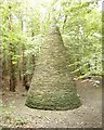
Pyramid in Edenhill Plantation near Beamish
Stone sculpture about 4-5m high constructed in 1996 by artist Colin Rose. This is part of a rural art scheme and was made using dry stone walling techniques. A steel pole was embedded into the ground initially and a line from the top of the pole to the ground was used to scribe the circle at the base.
Image: © John Bedlington
Taken: 1 May 2002
0.21 miles
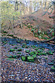
7
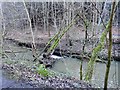
Fallen trees in the Beamish Burn
In Ousbrough Wood near Beamish.
Image: © Robert Graham
Taken: 6 Feb 2013
0.22 miles
8
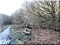
The Wheel Sculpture
Industrial sculpture beside the path through Ousbrough Wood near Beamish.
Image: © Robert Graham
Taken: 6 Feb 2013
0.23 miles
9
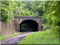
Eastern portal of old railway tunnel at Beamish
The old rail route through Beamish in County Durham now has the responsibility of carrying three named paths and cycle routes: the 'C2C Cycle Route', the 'Great North Forest Heritage Trail' and the 'Consett and Sunderland Railway Path'.
The tunnel seen here is one of two that follow in close succession neither of which cuts through particularly high ground; it's surprising that the route was tunnelled rather than cuttings being made.
Image: © Trevor Littlewood
Taken: 26 Jun 2012
0.24 miles
10
Industrial Ruins - dressed stone scatter
Image: © Mick Garratt
Taken: 21 Nov 2021
0.25 miles