IMAGES TAKEN NEAR TO
Hunstanworth, CONSETT, DH8 9UE
Introduction
This page details the photographs taken nearby to DH8 9UE by members of the Geograph project.
The Geograph project started in 2005 with the aim of publishing, organising and preserving representative images for every square kilometre of Great Britain, Ireland and the Isle of Man.

There are currently over 7.5m images from over14,400 individuals and you can help contribute to the project by visiting https://www.geograph.org.uk
Image Map
Images are licensed for reuse under creativecommons.org/licenses/by-sa/2.0
Notes
- Clicking on the map will re-center to the selected point.
- The higher the marker number, the further away the image location is from the centre of the postcode.
Image Listing (42 Images Found)
Images are licensed for reuse under creativecommons.org/licenses/by-sa/2.0
Image
Details
Distance
1
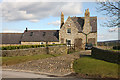
House in Hunstanworth
With a cobbled drive.
Image: © Helen Wilkinson
Taken: 6 Mar 2009
0.02 miles
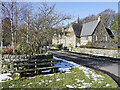
2
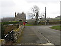
Road from St James' Church to main road in Hunstanworth
Looking north-eastward.
Image: © Peter Wood
Taken: 29 Mar 2017
0.03 miles
4
Semi-detached properties in Hunstanworth
Houses at the eastern end of the small settlement.
Image: © Trevor Littlewood
Taken: 15 Mar 2022
0.04 miles
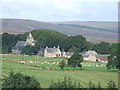
5
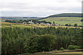
Hunstanworth from Bale Hill
Hunstanworth is one of the 'Thankful Villages' (a term popularised by the writer Arthur Mee in the 1930s) that suffered no fatalities during the Great War of 1914-1918. The unusual patterns in the roof tiles was a creation of architect Samuel Sanders Teulon who had been commissioned by Reverend Daniel Capper, landowner who would stay in Newbiggin Hall during the grouse shooting season, to build a new church, school, reading room, shop and workers' terraced cottages in 1863. The distinctive diamond-patterned, steep-pitched roofs and Victorian Gothic detail make Hunstanworth unique among the villages of the North Pennines. Closure of the local lead mines in the 1880s diminished the 800 strong population (778 in 1861) to just 200 by 1901. The population of the village in 2011 was 116. John Marius Wilson's Imperial Gazetteer of England and Wales of 1870-72 informs us that "the church was rebuilt in 1865, at a cost of £2,500".
Image: © Jo and Steve Turner
Taken: 24 Jul 2010
0.05 miles
6
Row of houses in Hunstanworth
The small settlement of Hunstanworth has hardly a dozen houses, several of them being in view in this image; they're on the north side of the only road. The top of the church tower rises above the roofs.
Image: © Trevor Littlewood
Taken: 4 Mar 2024
0.05 miles
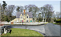
8
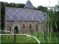
St James Church, Hunstanworth
This church was built in 1862-63 and replaced a smaller church that had been built in 1781. The Tower is 80 ft high with a pyramid roof originally crowned with gilt cardinals and a cock. The decorative slating of the roof is an interesting feature of this church.
Image: © Les Hull
Taken: 15 Jul 2004
0.06 miles
9
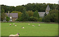
Across the sheep paddock to Hunstanworth
Image: © Kerry Rourke
Taken: 15 Sep 2007
0.07 miles
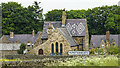
10
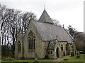
The Church of St James in Hunstanworth
Viewed from the south-west.
Image: © Peter Wood
Taken: 29 Mar 2017
0.07 miles