IMAGES TAKEN NEAR TO
Blanchland, CONSETT, DH8 9UD
Introduction
This page details the photographs taken nearby to DH8 9UD by members of the Geograph project.
The Geograph project started in 2005 with the aim of publishing, organising and preserving representative images for every square kilometre of Great Britain, Ireland and the Isle of Man.

There are currently over 7.5m images from over14,400 individuals and you can help contribute to the project by visiting https://www.geograph.org.uk
Image Map
Images are licensed for reuse under creativecommons.org/licenses/by-sa/2.0
Notes
- Clicking on the map will re-center to the selected point.
- The higher the marker number, the further away the image location is from the centre of the postcode.
Image Listing (20 Images Found)
Images are licensed for reuse under creativecommons.org/licenses/by-sa/2.0
Image
Details
Distance
2
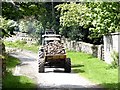
Trailer full of fodder root crops
Near Newbiggin Farm. The particular crop has not been identified.
Image: © Oliver Dixon
Taken: 14 May 2020
0.03 miles
3
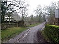
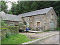
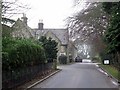
Track at Newbiggin
Newbiggin House is on the left.
Image: © Andrew Curtis
Taken: 9 Jan 2018
0.04 miles
4
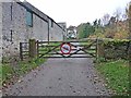
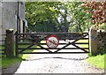
Gate at Newbigin
A good farm road leads from Baybridge up to the old hunting lodge at Riddlehamhope, but only carries the status of public footpath. The landowners seem pretty anti its use by cyclists, thereby severing a good link for off-road cyclists between the Derwent valley and the Devil's Water.
Image: © Oliver Dixon
Taken: 7 Nov 2011
0.05 miles
5
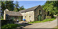
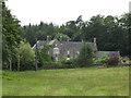
Barns at east end of Long Plantation
Barns at the west end of the estate buildings at Newbiggin. The estate road passing by heads on into the valley of the Beldon Burn where it contours well above the valley bottom.
Image: © Trevor Littlewood
Taken: 15 Jun 2023
0.05 miles
7
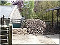
Large stock of fodder root crop at Newbiggin Farm
The root crop has not been identified.
Image: © Oliver Dixon
Taken: 14 May 2020
0.06 miles
8
No cycling!
There is a strong emphasis on banning cyclists from using the estate road up the valley of the Beldon Burn which only carries the status of public footpath. A pity, as it could form a useful link between the valley of the Devil's Water and the Derwent valley.
Image: © Oliver Dixon
Taken: 14 May 2020
0.07 miles
9
Road near Newbiggin
The lodge house is on the left, just past the entrance to Newbiggin Hall.
Image: © Andrew Curtis
Taken: 9 Jan 2018
0.08 miles
10
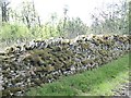
Mossy wall near Newbiggin Farm
An interesting pattern of moss has accumulated on this stone wall.
Image: © Oliver Dixon
Taken: 14 May 2020
0.10 miles