IMAGES TAKEN NEAR TO
Blanchland, CONSETT, DH8 9SZ
Introduction
This page details the photographs taken nearby to DH8 9SZ by members of the Geograph project.
The Geograph project started in 2005 with the aim of publishing, organising and preserving representative images for every square kilometre of Great Britain, Ireland and the Isle of Man.

There are currently over 7.5m images from over14,400 individuals and you can help contribute to the project by visiting https://www.geograph.org.uk
Image Map
Images are licensed for reuse under creativecommons.org/licenses/by-sa/2.0
Notes
- Clicking on the map will re-center to the selected point.
- The higher the marker number, the further away the image location is from the centre of the postcode.
Image Listing (13 Images Found)
Images are licensed for reuse under creativecommons.org/licenses/by-sa/2.0
Image
Details
Distance
1
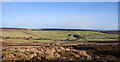
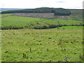
Across valley of Reeding Burn to Birkside
The buildings at Birkside are around the trees to the right of centre in the image. Much of the land in the valley is in agricultural use.
Image: © Trevor Littlewood
Taken: 27 Jan 2020
0.02 miles
2
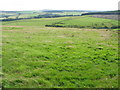
The valley of Reeding Burn (2)
Birkside is hidden below the first horizon. Part of Whitehill Plantation can be seen on the far side of the valley (right) along with evidence of former mine workings in some of the fields.
Image: © Mike Quinn
Taken: 25 Jul 2007
0.05 miles
4
Field with sheep above the valley of the Reeding Burn
Image: © Oliver Dixon
Taken: 14 May 2020
0.12 miles
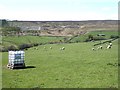
5

Sheep pasture above Birkside
At the head of the Reeding Burn valley.
Image: © Karl and Ali
Taken: 25 May 2017
0.13 miles
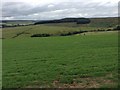
6
The valley of Reeding Burn and Whitehill Plantation
Image: © Mike Quinn
Taken: 25 Jul 2007
0.15 miles
7
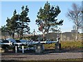
Gas relay station
A major gas pipeline installation at the top of the hill above Baybridge.
Image: © Oliver Dixon
Taken: 7 Nov 2011
0.20 miles
8
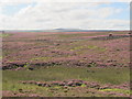
Birkside Fell north of Newbiggin
Looking south towards Image (photographed by Colin Blackburn).
Image: © Mike Quinn
Taken: 22 Aug 2011
0.21 miles
9
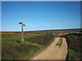
Track junction, Bulbeck Common
Bridleway left, shooters' track straight ahead.
Image: © Karl and Ali
Taken: 25 May 2017
0.22 miles
10
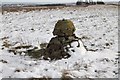
Gas Pipeline Marker, Birkside Fell
A curious marker for major mains gas pipe. Internally it looks like a
concrete bollard but has facing stones giving it a decorative appearance.
The top is curiously flattened. Maybe it was also used as a surveying station?
Image: © Tony Campbell
Taken: 13 Dec 2014
0.22 miles