IMAGES TAKEN NEAR TO
Kiln Pit Hill, CONSETT, DH8 9SH
Introduction
This page details the photographs taken nearby to DH8 9SH by members of the Geograph project.
The Geograph project started in 2005 with the aim of publishing, organising and preserving representative images for every square kilometre of Great Britain, Ireland and the Isle of Man.

There are currently over 7.5m images from over14,400 individuals and you can help contribute to the project by visiting https://www.geograph.org.uk
Image Map (Loading...)


Getting Data...Please wait
Leaflet Map data © OpenStreetMap
Images are licensed for reuse under creativecommons.org/licenses/by-sa/2.0
Notes
- Clicking on the map will re-center to the selected point.
- The higher the marker number, the further away the image location is from the centre of the postcode.
Image Listing (12 Images Found)
Images are licensed for reuse under creativecommons.org/licenses/by-sa/2.0
Image
Details
Distance
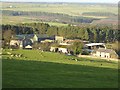
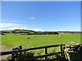
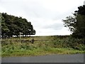
2
Fairley Farm
Looking down the road to the farm. Union Wood Image is on the far side of the valley in the distance
Image: © Oliver Dixon
Taken: 8 Jan 2015
0.02 miles
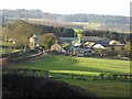
3

Fairley Farm viewed from the road
View from the Whittonstall road. The farm occupies the site of a medieval village, but nothing remains from early times. Only the farm is here now and that is probably early C19.
Image: © Robert Graham
Taken: 24 Aug 2016
0.05 miles
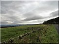
4
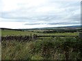
View over the Tyne valley
Looking to the north from the side of the Whittonstall road over the fields near Fairley Farm. There are fine views from here over the Tyne valley from the top of the southern slope.
Image: © Robert Graham
Taken: 20 Sep 2017
0.06 miles
5
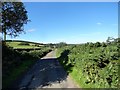
Road to Fairley Farm
The farm lies at the end of this track, a little way north of the Kiln Pit Hill to Whittonstall road.
Image: © Robert Graham
Taken: 24 Aug 2016
0.09 miles
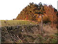
6
Grazing pasture to the west of the road
This is beside the lane running north to the Bridges. The large farmstead in the distance is Fairley Farm.
Image: © Robert Graham
Taken: 24 Aug 2016
0.15 miles
7
View along the Whittonstall road
View to the northeast across to the Tyne valley in the distance.
Image: © Robert Graham
Taken: 20 Sep 2017
0.19 miles
9
Footpath from Fell Road to Highfield Farm Lane
For some reason the location of the path does not match the Ordnance Survey map. The OS dotted line marks the location probably before the Open cast mining of the 1970s.
Image: © Clive Nicholson
Taken: 18 Oct 2009
0.21 miles
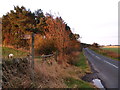
10
Footpath sign
Start of the public path which leads south across the fields from the Whittonstall road to the farm road to Highfield.
Image: © Robert Graham
Taken: 20 Sep 2017
0.22 miles