IMAGES TAKEN NEAR TO
Blanchland, CONSETT, DH8 9PP
Introduction
This page details the photographs taken nearby to DH8 9PP by members of the Geograph project.
The Geograph project started in 2005 with the aim of publishing, organising and preserving representative images for every square kilometre of Great Britain, Ireland and the Isle of Man.

There are currently over 7.5m images from over14,400 individuals and you can help contribute to the project by visiting https://www.geograph.org.uk
Image Map
Images are licensed for reuse under creativecommons.org/licenses/by-sa/2.0
Notes
- Clicking on the map will re-center to the selected point.
- The higher the marker number, the further away the image location is from the centre of the postcode.
Image Listing (10 Images Found)
Images are licensed for reuse under creativecommons.org/licenses/by-sa/2.0
Image
Details
Distance
1
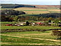
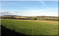
Allenshields
View from south-east over Near Haw Burn.
Image: © Andrew Curtis
Taken: 17 Oct 2014
0.01 miles
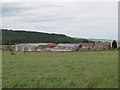
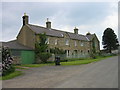
2
Allenshields Farm
A large farm on the hillside above Blanchland.
Image: © Oliver Dixon
Taken: 2 Aug 2008
0.02 miles
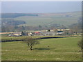
5
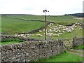
Sheep at Allenshields Farm
A heavy concentration of sheep in a field across the road from Allenshields Farm. Note the weather-vane, topped by a tractor.
Image: © Oliver Dixon
Taken: 27 Jul 2011
0.03 miles
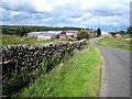
7
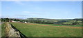
Allenshields Farm
View looking across pasture at Allenfields Farm with Newbiggin Fell in the background.
Image: © Peter McDermott
Taken: 26 Aug 2007
0.13 miles
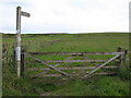
10
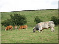
Friendly bull on public footpath near Allenshields
Image: © Mike Quinn
Taken: 25 Jul 2007
0.24 miles