IMAGES TAKEN NEAR TO
Edmundbyers, CONSETT, DH8 9NW
Introduction
This page details the photographs taken nearby to DH8 9NW by members of the Geograph project.
The Geograph project started in 2005 with the aim of publishing, organising and preserving representative images for every square kilometre of Great Britain, Ireland and the Isle of Man.

There are currently over 7.5m images from over14,400 individuals and you can help contribute to the project by visiting https://www.geograph.org.uk
Image Map
Images are licensed for reuse under creativecommons.org/licenses/by-sa/2.0
Notes
- Clicking on the map will re-center to the selected point.
- The higher the marker number, the further away the image location is from the centre of the postcode.
Image Listing (107 Images Found)
Images are licensed for reuse under creativecommons.org/licenses/by-sa/2.0
Image
Details
Distance
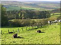
2
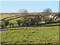
Farm at Edmundbyers
This farm lies on the western edge of the village. Beyond it, to the south, lie the moors of Muggleswick Common.
Image: © Robert Graham
Taken: 1 May 2013
0.02 miles
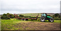
3
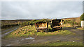
Trailers used as wood stores
On the western periphery of Edmundbyers where a hill road splits these trailers were parked, each with a quantity of chopped or sawn wood, presumably for domestic burning.
Image: © Trevor Littlewood
Taken: 7 Dec 2019
0.04 miles
4
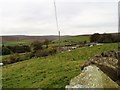
View from Hepple Hill, Edmundbyers
This is a view west from the B6306 road leading up Hepple Hill on the north side of Edmundbyers village. The view looks over The Hole farm in the foreground up the valley of the Burnhope Burn to the moors of Muggleswick Common in the distance.
Image: © Robert Graham
Taken: 21 Oct 2019
0.06 miles
5
Two ponies at Black Hill, Edmundbyers
Overlooking the valley of the Burnhope Burn. The B6278 can be seen on the far side climbing up to Park Head.
Image: © Oliver Dixon
Taken: 1 Nov 2013
0.06 miles
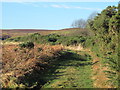
6
Tractor with low trailer
The vehicles were parked at a small area of access land named as Black Hill which lies just to the west of Edmundbyers.
Image: © Trevor Littlewood
Taken: 10 Sep 2020
0.07 miles
8
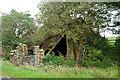
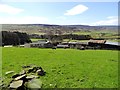
Edmundbyers
Derelict building in Edmundbyers.
Image: © Peter McDermott
Taken: 31 Aug 2008
0.09 miles
9
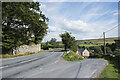
Road junction in Edmundbyers
Church Lane branching from the B6306 and descending.
Image: © Trevor Littlewood
Taken: 5 Aug 2021
0.10 miles
10
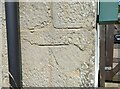
Edmundbyers, house on hill
This house is on the north side of the B6306, which runs through Edmundbyers and onto Blanchland. On this south-facing wall, there is the remains of a faint mark of a damaged benchmark. The cut is on the far right corner stone of the front of the property, to the right of the drainpipe.
Image: © Mel Towler
Taken: 21 Jul 2021
0.10 miles