IMAGES TAKEN NEAR TO
Edmundbyers, CONSETT, DH8 9NB
Introduction
This page details the photographs taken nearby to DH8 9NB by members of the Geograph project.
The Geograph project started in 2005 with the aim of publishing, organising and preserving representative images for every square kilometre of Great Britain, Ireland and the Isle of Man.

There are currently over 7.5m images from over14,400 individuals and you can help contribute to the project by visiting https://www.geograph.org.uk
Image Map
Images are licensed for reuse under creativecommons.org/licenses/by-sa/2.0
Notes
- Clicking on the map will re-center to the selected point.
- The higher the marker number, the further away the image location is from the centre of the postcode.
Image Listing (4 Images Found)
Images are licensed for reuse under creativecommons.org/licenses/by-sa/2.0
Image
Details
Distance
1
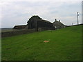
Lamb Shield Farm
The farm buildings at Lamb Shield lie to the east of Stoterley Hill. They're seen in this image from a path beside a wall to the south-east.
Image: © Trevor Littlewood
Taken: 4 Nov 2021
0.01 miles
2

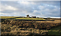
Lamb Shield Farm
An isolated farm to the south of Edmundbyers village. Snow lingers at the foot of the walls on the north side.
Image: © Oliver Dixon
Taken: 15 Dec 2014
0.01 miles
3
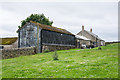
Lamb Shield
Lamb Shield is a farm high, (over 350 metres above sea level), on the south side of the Derwent valley close to Edmondbyers
Image: © Trevor Littlewood
Taken: 2 Jul 2020
0.02 miles