IMAGES TAKEN NEAR TO
CONSETT, DH8 9HW
Introduction
This page details the photographs taken nearby to DH8 9HW by members of the Geograph project.
The Geograph project started in 2005 with the aim of publishing, organising and preserving representative images for every square kilometre of Great Britain, Ireland and the Isle of Man.

There are currently over 7.5m images from over14,400 individuals and you can help contribute to the project by visiting https://www.geograph.org.uk
Image Map
Images are licensed for reuse under creativecommons.org/licenses/by-sa/2.0
Notes
- Clicking on the map will re-center to the selected point.
- The higher the marker number, the further away the image location is from the centre of the postcode.
Image Listing (20 Images Found)
Images are licensed for reuse under creativecommons.org/licenses/by-sa/2.0
Image
Details
Distance
1
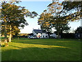
Bee Cottage Guest House
Set in peaceful, picturesque surroundings on the edge of the beautiful Durham Dales.
Image: © Eirian Evans
Taken: 20 Sep 2019
0.01 miles
2
Bee Cottage Guesthouse
A farmhouse which has been converted into a stylish guesthouse. http://www.beecottage.co.uk Located near to and originally conceived as a service for the C2C cycle route. However, the current publicity makes no mention of the proximity to the C2C and is making its appeal to a much wider, car-borne clientele.
Image: © Oliver Dixon
Taken: 6 Mar 2007
0.01 miles
3
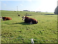
Bee Cottage Farm
Viewed from the track from Oxen Law. A lot of snow lying here in mid March.
Image: © Robert Graham
Taken: 13 Mar 2013
0.03 miles
4
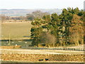
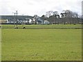
Farmland at Bees Cottage
Farmland at Bees Cottage looking towards the Bonner Plantation
Image: © Keith Havercroft
Taken: 10 Apr 2006
0.13 miles
5
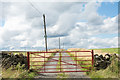
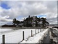
Access to Red House beyond red gate
OS maps show the road as an "Other Route with Public Access". It seems that the occupiers of the farm don't necessarily see it that way... there's a notice fixed to a pole, set high and out of reach, that tells "Private Road No Entry". Now there probably is no public motor access along the way but there's a padlock on the gate which would prevent that anyway. The lock also means that the gate has to be climbed by pedestrians!
Image: © Trevor Littlewood
Taken: 8 Aug 2018
0.16 miles
6
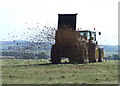
Muck Spreading
Muck spreading on fields at Red House Farm.
Image: © Peter McDermott
Taken: 8 Sep 2007
0.18 miles
7
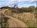
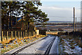
Waskerley Way near Redhouse Farm
For much of the eastern end of the C2C National Cycle Route (route 7) http://www.c2c-guide.co.uk , the route follows old railway tracks, including the Waskerley Way which follows the old Stanhope and Tyne railway from Park Head down to Consett and beyond. Rather than tackle the problem of draining the trackbed in the cutting ahead at this point, the path has been diverted up to a higher level.
Image: © Oliver Dixon
Taken: 1 Nov 2013
0.22 miles
9
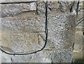
Ordnance Survey Cut Mark
This OS cut mark can be found on the south face of house at Oxen Law. It marks a point 327.819m above mean sea level.
Image: © Adrian Dust
Taken: 18 Sep 2018
0.22 miles