IMAGES TAKEN NEAR TO
Knitsley, CONSETT, DH8 9EU
Introduction
This page details the photographs taken nearby to DH8 9EU by members of the Geograph project.
The Geograph project started in 2005 with the aim of publishing, organising and preserving representative images for every square kilometre of Great Britain, Ireland and the Isle of Man.

There are currently over 7.5m images from over14,400 individuals and you can help contribute to the project by visiting https://www.geograph.org.uk
Image Map
Images are licensed for reuse under creativecommons.org/licenses/by-sa/2.0
Notes
- Clicking on the map will re-center to the selected point.
- The higher the marker number, the further away the image location is from the centre of the postcode.
Image Listing (25 Images Found)
Images are licensed for reuse under creativecommons.org/licenses/by-sa/2.0
Image
Details
Distance
1
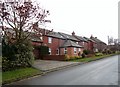
Dkye Nook Cottages
A little row of houses on Outputs Lane, south of Consett. They must take their name from the farm on the other side of the road.
Image: © Robert Graham
Taken: 25 Feb 2015
0.01 miles
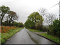
3
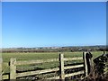
Roadside view on Outputs Lane
Countryside south of the lane, next to New House Farm.
Image: © Robert Graham
Taken: 3 Oct 2022
0.06 miles
4
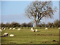
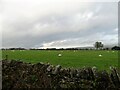
Grazing sheep beside Outputs Lane
Grazing field west of Dyke Nook farm. Pastoral farming is the main occupation of the land around here.
Image: © Robert Graham
Taken: 3 Feb 2020
0.07 miles
5
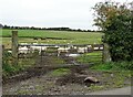
Sheep through the gateway
Sheep grazing beside Outputs Lane. Mainly pastoral farming in this area, with sheep and beef cattle.
Image: © Robert Graham
Taken: 3 Oct 2022
0.09 miles
6
Roadside fence on Outputs Lane
This is a scene to the west of Dyke Nook farm looking north towards Delves Lane. Most of the land around here is pasture land for sheep and cattle, as here.
Image: © Robert Graham
Taken: 3 Feb 2020
0.09 miles
7
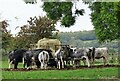
Cattle at feeder
South of Outputs Lane. Much of the farmland around here is pastoral, with sheep and beef cattle.
Image: © Robert Graham
Taken: 3 Oct 2022
0.10 miles
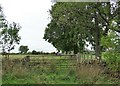
8
Little valley south of Outputs Lane
Near New House Farm. The little stream here runs into the Knitsley Burn just to the north.
Image: © Robert Graham
Taken: 5 Sep 2018
0.10 miles
9
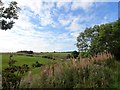
Grazing field beside Outputs Lane
On the north side, just west of Dyke Nook farm. The farmland around here has an upland feel due to the mainly pastoral use and the dry stone walls along the roadside.
Image: © Robert Graham
Taken: 20 Oct 2020
0.11 miles
10
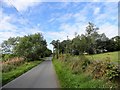
View west along Outputs Lane
The trees on the right line the entrance to Dyke Nook farm.
Image: © Robert Graham
Taken: 5 Sep 2018
0.11 miles