IMAGES TAKEN NEAR TO
Muggleswick, CONSETT, DH8 9DP
Introduction
This page details the photographs taken nearby to DH8 9DP by members of the Geograph project.
The Geograph project started in 2005 with the aim of publishing, organising and preserving representative images for every square kilometre of Great Britain, Ireland and the Isle of Man.

There are currently over 7.5m images from over14,400 individuals and you can help contribute to the project by visiting https://www.geograph.org.uk
Image Map
Images are licensed for reuse under creativecommons.org/licenses/by-sa/2.0
Notes
- Clicking on the map will re-center to the selected point.
- The higher the marker number, the further away the image location is from the centre of the postcode.
Image Listing (25 Images Found)
Images are licensed for reuse under creativecommons.org/licenses/by-sa/2.0
Image
Details
Distance
1
House in gorge of River Derwent
To the west of Castleside the River Derwent flows in a remarkable series of incised meanders; this house lies among them, north of a footbridge across the flow.
Image: © Trevor Littlewood
Taken: 22 Nov 2008
0.01 miles
2
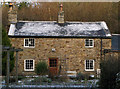
Lead Mill
This is a small farmhouse with no visible evidence of its prior association with lead processing although it may have been associated with the nearby Silvertongue Mine.
https://www.nmrs.org.uk/assets/pdf/BM48/BM48-93-103-crooked.pdf gives details but is inconclusive in my view as to whether the building housed the mill from which it derives its name.
Image: © Alan Murray-Rust
Taken: 28 Dec 2016
0.01 miles
3
Cottage at Derwent Gorge
This cottage is in an idyllic spot beside the river in Muggleswick Woods, although rather isolated. View taken from the rough access road which runs down through the woods from Crooked Oak farm.
Image: © Robert Graham
Taken: 16 Apr 2012
0.02 miles
4

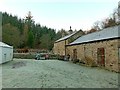
Lime kiln at Lead Mill, Muggleswick ? 1
Two-draw kiln in a poor state of repair. The kiln is on private land at the back of Lead Mill and was photographed with permission. I was told that the right hand draw arch had collapsed since they moved into the premises about 10 years earlier. Listed Grade II.
Image: © Alan Murray-Rust
Taken: 28 Dec 2016
0.03 miles
5

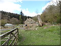
Lime kiln at Lead Mill, Muggleswick ? 2
The remaining complete draw arch. See also http://www.geograph.org.uk/photo/5245368.
Image: © Alan Murray-Rust
Taken: 28 Dec 2016
0.03 miles
6

Lime kiln at Lead Mill, Muggleswick ? 3
The collapsed right hand draw arch; tree growth is the principal culprit. See also http://www.geograph.org.uk/photo/5245368.
Image: © Alan Murray-Rust
Taken: 28 Dec 2016
0.03 miles
7
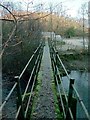
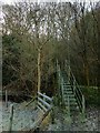
Leadmill footbridge
This consists of a narrow concrete beam crossing quite high above the River Derwent. It may originated as a quarrymen's/miners' path. Consistently mapped as Leadmill Bridge although the small farmstead is named Lead Mill.
Image: © Alan Murray-Rust
Taken: 28 Dec 2016
0.03 miles
8
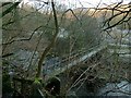
Leadmill footbridge
This crosses quite high above the River Derwent, not so much to be clear of floodwaters as to find a suitable abutment on the steep side of the gorge.
Image: © Alan Murray-Rust
Taken: 28 Dec 2016
0.04 miles
9
Leadmill footbridge
This crosses quite high above the River Derwent.
Image: © Alan Murray-Rust
Taken: 28 Dec 2016
0.04 miles
10
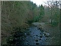
River Derwent at Lead Mill, Muggleswick
The woodland is part of the Derwent Gorge and Muggleswick Woods National Nature Reserve. At this time of year it is doubtful if the sun ever gets onto this stretch of the river.
Image: © Alan Murray-Rust
Taken: 28 Dec 2016
0.05 miles