IMAGES TAKEN NEAR TO
Welford Road, CONSETT, DH8 8AH
Introduction
This page details the photographs taken nearby to Welford Road, DH8 8AH by members of the Geograph project.
The Geograph project started in 2005 with the aim of publishing, organising and preserving representative images for every square kilometre of Great Britain, Ireland and the Isle of Man.

There are currently over 7.5m images from over14,400 individuals and you can help contribute to the project by visiting https://www.geograph.org.uk
Image Map
Images are licensed for reuse under creativecommons.org/licenses/by-sa/2.0
Notes
- Clicking on the map will re-center to the selected point.
- The higher the marker number, the further away the image location is from the centre of the postcode.
Image Listing (11 Images Found)
Images are licensed for reuse under creativecommons.org/licenses/by-sa/2.0
Image
Details
Distance
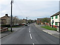
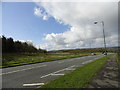
1
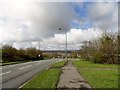
Junction on the A692
The road on the right leads off the A692 here to The Grove, the large housing estate to the west of Consett town centre. In the distance can be seen the village of Castleside and beyond, the moors of the Pennine foothills.
Image: © Robert Graham
Taken: 13 Apr 2012
0.12 miles
2
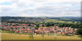
Three Groups of Housing
Foreground is The Grove, then Moorside and next Castleside which is on the A68. Photograph was taken on the site of the former steel works, which is now landscaped.
Image: © Dennis Lovett
Taken: 2 Aug 2005
0.13 miles
4
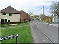
Grassed area beside The Grove Primary School
The Grove is a residential area, perhaps a village in its own right, between Consett and Moorside. The school lies out of view down the slope to the left.
Image: © Trevor Littlewood
Taken: 1 Feb 2015
0.18 miles
5
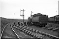
Unusual activity at Consett engine shed
My recollection is that the problem was that the tender brakes had seized, and a team of men was trying to free them. The loco is Q6 0-8-0 63394, built around 1913 by the North Eastern Railway. The locomotive shed is hidden behind the locomotive.
The landscape today is rather different! https://www.geograph.org.uk/photo/4976021 . Only the availability of old OS maps on the internet makes it possible to locate a view like this accurately.
Image: © Alan Murray-Rust
Taken: 14 Apr 1965
0.21 miles
6
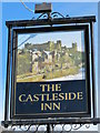
Sign for er... The Stanefordham Inn, Moorside
See Image The pub was formerly known as the Castleside Inn.
Image: © Mike Quinn
Taken: 5 Apr 2011
0.23 miles
8
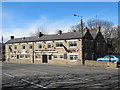
The Stanefordham Inn, Moorside
According to the Evening Gazettes http://evening-gazettes.com/archives/3833 and the Chronicle http://www.chroniclelive.co.uk/north-east-news/evening-chronicle-news/2011/01/19/police-find-40-000-of-cannabis-in-searches-72703-28014275/, the landlord of this pub was recently caught with a £40,000 cannabis farm in one of the bedrooms.
Image: © Mike Quinn
Taken: 5 Apr 2011
0.24 miles
9
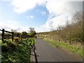
Path to Lydgett's Junction
This is the last section of the Derwent Walk, just before it joins the Waskerley Way at the junction. View looking south.
Image: © Robert Graham
Taken: 13 Apr 2012
0.25 miles
10
Looking down the A692
Looking West down this road which is the main road out to the West from Consett. It connects with the A68 at Castleside, which is visible in the distance.
Image: © Robert Graham
Taken: 13 Apr 2012
0.25 miles