IMAGES TAKEN NEAR TO
Holwick Close, CONSETT, DH8 7UH
Introduction
This page details the photographs taken nearby to Holwick Close, DH8 7UH by members of the Geograph project.
The Geograph project started in 2005 with the aim of publishing, organising and preserving representative images for every square kilometre of Great Britain, Ireland and the Isle of Man.

There are currently over 7.5m images from over14,400 individuals and you can help contribute to the project by visiting https://www.geograph.org.uk
Image Map (Loading...)


Getting Data...Please wait
Leaflet Map data © OpenStreetMap
Images are licensed for reuse under creativecommons.org/licenses/by-sa/2.0
Notes
- Clicking on the map will re-center to the selected point.
- The higher the marker number, the further away the image location is from the centre of the postcode.
Image Listing (8 Images Found)
Images are licensed for reuse under creativecommons.org/licenses/by-sa/2.0
Image
Details
Distance
1
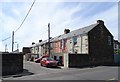
Alwyn Terrace, Templetown
These old terraces date to the early 20th century. Originally, they were surrounded by the buildings of Consett Steelworks.
Image: © Robert Graham
Taken: 26 May 2020
0.18 miles
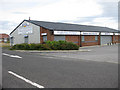
3
Builders merchants at Templetown
This building has been put to new use since Consett Steelworks closed in the 1980's. It was originally an electricity generating station for the steelworks.
Image: © Robert Graham
Taken: 2 Jan 2014
0.24 miles
4
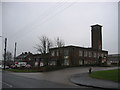
Old Fire Station at Delves
An old Fire Station at Delves now converted for use as a repair garage.
Image: © Colin Edgar
Taken: 8 Jan 2006
0.24 miles
5
Bescol premises, Delves Lane
DIY supplies to trade and public, amongst other products.
Image: © Pauline E
Taken: 24 Jul 2009
0.24 miles
6
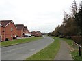
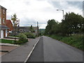
New houses at Templetown
This is part of the Chequers estate built in recent years on the site of the former Consett steelworks. Many new houses have been built on the south side of the town centre on reclaimed industrial land.
Image: © Robert Graham
Taken: 10 Apr 2019
0.25 miles
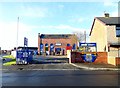
7
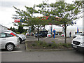
Filling station, Consett
Run by Tesco.
Update - 2013: this branch of Tesco has now closed and a much bigger store has opened in the town.
Image: © Pauline E
Taken: 24 Jul 2009
0.25 miles
8
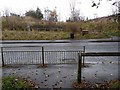
Consett and Sunderland path crossing Knitsley Lane
The Consett and Sunderland railway path (part of the famous C2C cycle route, National Cycle Network route 7) crossing Knitsley Lane at grade.
Image: © Oliver Dixon
Taken: 13 Nov 2012
0.25 miles