IMAGES TAKEN NEAR TO
St. Ives Road, CONSETT, DH8 7SJ
Introduction
This page details the photographs taken nearby to St. Ives Road, DH8 7SJ by members of the Geograph project.
The Geograph project started in 2005 with the aim of publishing, organising and preserving representative images for every square kilometre of Great Britain, Ireland and the Isle of Man.

There are currently over 7.5m images from over14,400 individuals and you can help contribute to the project by visiting https://www.geograph.org.uk
Image Map
Images are licensed for reuse under creativecommons.org/licenses/by-sa/2.0
Notes
- Clicking on the map will re-center to the selected point.
- The higher the marker number, the further away the image location is from the centre of the postcode.
Image Listing (50 Images Found)
Images are licensed for reuse under creativecommons.org/licenses/by-sa/2.0
Image
Details
Distance
1
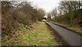
Consett and Sunderland Railway Path east of Leadgate
This stretch of the Consett and Sunderland Railway Path is also part of the National Cycle Network route; hence, no doubt, the need for the tarmac surface.
Image: © Trevor Littlewood
Taken: 23 Jan 2016
0.03 miles
2
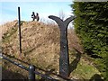
NCN milepost at the "Jolly Drovers", Leadgate
The Consett and Sunderland path (part of the famous C2C cycle route, National Cycle Network route 7) follows the line of an old railway from Stanhope Moor down to Washington.
The milepost is one of a thousand donated by the Royal Bank of Scotland to the project. This particular design is "Fossil Tree" by John Mills, and is sometimes known as the "English" milepost, although examples of it may be found throughout the United Kingdom. The structure on top of the mound is supposed to be a "viewing point" for the Leadgate Maze Image on the other side of the "Jolly Drovers" roundabout.
Image: © Oliver Dixon
Taken: 28 Feb 2014
0.03 miles
3
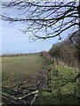
View from beside the old railway at Leadgate
A view of Pontop Pike in the distance with its TV mast.
Image: © Robert Graham
Taken: 22 Mar 2021
0.03 miles
4

Redwell Hills Farm, Leadgate
Old Victorian farm at the eastern end of the village.
Image: © Robert Graham
Taken: 18 Feb 2014
0.03 miles
5
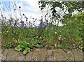
Harebells on top of the wall
Beside the Consett and Sunderland Railway Path at Leadgate.
Image: © Robert Graham
Taken: 20 Jul 2020
0.04 miles
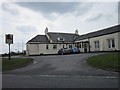
6
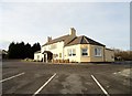
The Jolly Drovers, Leadgate
This popular pub and restaurant closed a couple of years ago but fortunately was bought by new owners and had a major revamp. It seems to be doing very well, which makes a nice change to the usual story of local pubs being lost for ever.
Image: © Robert Graham
Taken: 30 Nov 2016
0.05 miles
7
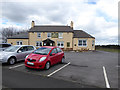
"Jolly Drovers", Leadgate
Now fortunately returned to full operation, a popular watering hole on the Consett and Sunderland railway path. See also the sorry state of same establishment back in 2012 Image
Image: © Oliver Dixon
Taken: 29 Apr 2015
0.05 miles
9
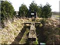
Leadgate Maze viewing platform
The Consett and Sunderland path (part of the famous C2C cycle route, National Cycle Network route 7) follows the line of an old railway from Stanhope Moor down to Washington. At this point the embankment is cut by road construction around the roundabout at the eastern end of the Leadgate By-pass (A692) ("Jolly Drovers" roundabout).
The structure at the end of the embankment is supposed to be a "viewing point" for the Leadgate Maze Image on the other side of the roundabout. Unfortunately, it no longer serves this purpose as the view has been very effectively blocked by a row of fast-growing leylandii trees which have been planted along the south side of the carpark of the "Jolly Drovers".
Image: © Oliver Dixon
Taken: 28 Feb 2014
0.06 miles
10
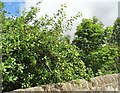
Crab Apples on the old line
Growing beside the railway path in Leadgate.
Image: © Robert Graham
Taken: 20 Jul 2020
0.06 miles