IMAGES TAKEN NEAR TO
Victory Close, DH8 7FB
Introduction
This page details the photographs taken nearby to Victory Close, DH8 7FB by members of the Geograph project.
The Geograph project started in 2005 with the aim of publishing, organising and preserving representative images for every square kilometre of Great Britain, Ireland and the Isle of Man.

There are currently over 7.5m images from over14,400 individuals and you can help contribute to the project by visiting https://www.geograph.org.uk
Image Map
Images are licensed for reuse under creativecommons.org/licenses/by-sa/2.0
Notes
- Clicking on the map will re-center to the selected point.
- The higher the marker number, the further away the image location is from the centre of the postcode.
Image Listing (10 Images Found)
Images are licensed for reuse under creativecommons.org/licenses/by-sa/2.0
Image
Details
Distance
1
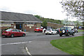
Shop on Gloucester Road
Top end of Delves/Crookhall.
Image: © Pauline E
Taken: 1 Jun 2013
0.06 miles
2
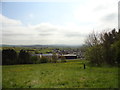
View from above Crookhall
Looking southeast from above the former mining community of Crookhall. Splendid views are to had from here looking down to Lanchester and beyond.
Image: © Robert Graham
Taken: 20 May 2012
0.06 miles
3
Cottages at Crookhall
These terraced bungalows were originally built for the miners of Crookhall Colliery by Consett Iron Company, which owned the pit. A lot of similar housing is dotted around Consett, all built by the Company.
Image: © Robert Graham
Taken: 20 May 2012
0.13 miles
4
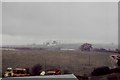
Consett Iron Works
Taken in the 1970's. Where from unknown at this distance in time. Someone may be able to identify the position of the photographer.
Image: © N T Stobbs
Taken: Unknown
0.13 miles
5
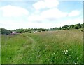
Rough meadowland at Crookhall
A rough field next to the houses at Crookhall. Looking north along the path.
Image: © Robert Graham
Taken: 3 Aug 2021
0.17 miles
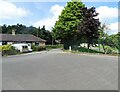
6
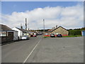
Top end of Main Street in Crookhall
Crookhall is a small suburb of Consett and consists mainly of a compact estate of terraced bungalows. Main street, shown here, ends in a wider area used as a turning circle for the buses, although it is not a cul-de-sac.
Image: © Robert Graham
Taken: 3 Aug 2021
0.20 miles
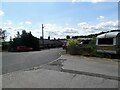
7
Turning circle at Crookhall
Crookhall is a small suburb of Consett. The main street ends in this wider area which is used as a turning circle for the buses.
Image: © Robert Graham
Taken: 3 Aug 2021
0.21 miles
8
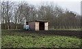
Wooden shelter in field
A shelter for horses in a small enclosure at Crookhall; the large plastic cube beside the building is a water container.
Image: © Trevor Littlewood
Taken: 23 Jan 2016
0.22 miles
9
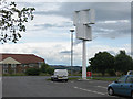
Vertical axis wind turbine
Turning merrily at Tesco premises, Consett. As their marketing department keep telling us, 'Every little helps.'
It's a Rotapec WindRotor and stands at about the same height as the nearby lamp post.
I asked someone in the car park what this was and was told it was a sculpture!
Update - 2011: This has been removed from the car park
Update - 2013: this branch of Tesco has now closed and a much bigger store has opened in the town.
Image: © Pauline E
Taken: 24 Jul 2009
0.22 miles
10
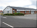
Bescol premises, Delves Lane
DIY supplies to trade and public, amongst other products.
Image: © Pauline E
Taken: 24 Jul 2009
0.24 miles