IMAGES TAKEN NEAR TO
Derwent View, CONSETT, DH8 6RA
Introduction
This page details the photographs taken nearby to Derwent View, DH8 6RA by members of the Geograph project.
The Geograph project started in 2005 with the aim of publishing, organising and preserving representative images for every square kilometre of Great Britain, Ireland and the Isle of Man.

There are currently over 7.5m images from over14,400 individuals and you can help contribute to the project by visiting https://www.geograph.org.uk
Image Map
Images are licensed for reuse under creativecommons.org/licenses/by-sa/2.0
Notes
- Clicking on the map will re-center to the selected point.
- The higher the marker number, the further away the image location is from the centre of the postcode.
Image Listing (59 Images Found)
Images are licensed for reuse under creativecommons.org/licenses/by-sa/2.0
Image
Details
Distance
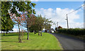
1
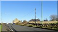
Looking along Medomsley Road
This road runs from the north side of Consett out to the junction with Corbridge Road near here. The old pub called the Hat and Feather stands at the junction, and is the white building in the distance.
Image: © Robert Graham
Taken: 25 Nov 2020
0.03 miles
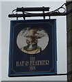
2
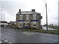
The Hat & Feather Inn
On the old Roman Dere Street.
Image: © JThomas
Taken: 2 Apr 2016
0.04 miles
4
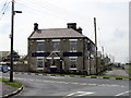
The Hat and Feather
Well known local pub which stands on a hill top near Leadgate. It is on the old Roman Dere Street.
Image: © Robert Graham
Taken: 1 Aug 2011
0.04 miles
6
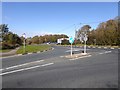
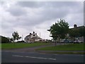
Intersection of Medomsley Road and Watling Street
Medomsley Road (B6308) (in the foreground) crosses Watling Street (B6309).
Image: © Oliver Dixon
Taken: 2 Oct 2018
0.08 miles
7
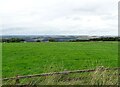
Grazing field next to Medomsley Road
With a fine view to the west over the Derwent Valley.
Image: © Robert Graham
Taken: 13 Sep 2021
0.08 miles
8
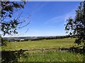
Hay field beside Medomsley Road
This field is beside the east end of the road, next to the junction with Elm Park Road. The hay has just been cut and will be left for a few days to dry.
Image: © Robert Graham
Taken: 24 Jun 2018
0.08 miles
9
Grassed area rising to Medomsley Road
The landscaped ground is climbing a slope beside Elm Park Road which meets the B6308, Medomsley Road, at the distant houses.
Image: © Trevor Littlewood
Taken: 4 Oct 2016
0.09 miles
10
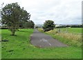
Re-aligned road
This now redundant short stretch of road resulted from the re-alignment of the east end of Elm Park Road at its junction with the B6308. The new route is on the right hand side of the picture, although hidden behind the bank.
Image: © Robert Graham
Taken: 4 Sep 2020
0.09 miles