IMAGES TAKEN NEAR TO
Highsteads, CONSETT, DH8 6QB
Introduction
This page details the photographs taken nearby to Highsteads, DH8 6QB by members of the Geograph project.
The Geograph project started in 2005 with the aim of publishing, organising and preserving representative images for every square kilometre of Great Britain, Ireland and the Isle of Man.

There are currently over 7.5m images from over14,400 individuals and you can help contribute to the project by visiting https://www.geograph.org.uk
Image Map
Images are licensed for reuse under creativecommons.org/licenses/by-sa/2.0
Notes
- Clicking on the map will re-center to the selected point.
- The higher the marker number, the further away the image location is from the centre of the postcode.
Image Listing (27 Images Found)
Images are licensed for reuse under creativecommons.org/licenses/by-sa/2.0
Image
Details
Distance
1
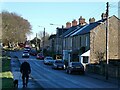
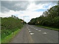
North View
The B6310 in Medomsley village.
Image: © Oliver Dixon
Taken: 16 Dec 2021
0.11 miles
2
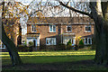
Houses from Fines Road
The houses are in the small 'pit village' of Medomsley in County Durham. They're viewed across the B6308, Fines Road, and are set back across an area of grass with mature trees.
Image: © Trevor Littlewood
Taken: 16 Nov 2015
0.11 miles
3
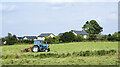
Grass being turned near to Medomsley
A small tractor turning grass in a small field at the south side of Medomsley. Presumably, the grass will be gathered and baled as hay or silage.
Image: © Trevor Littlewood
Taken: 5 Sep 2021
0.12 miles
4
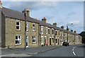
Fines Road cottages
Solid stone under slate roofs. Cottages alongside the B6308, Medomsley.
Image: © Pauline E
Taken: 9 Aug 2014
0.12 miles
5
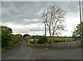
Lane leading off the B6310 at Medomsley
This lane runs north past The Dene on to High Westwood. On the west side of the village.
Image: © Robert Graham
Taken: 28 May 2021
0.14 miles
6
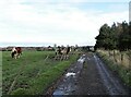
Horses beside a muddy path
This track leads across the fields east from Corbridge Road to Medomsley Edge. It crosses the site of the former Medomsley Colliery. The fields seem to be mostly used for grazing horses, as here.
Image: © Robert Graham
Taken: 18 Nov 2020
0.15 miles
7
Field beside the path to Medomsley Edge
View looking to the west from the path from Corbridge Road. In the distance is a view of the north side of the Derwent Valley centred on Wittonstall.
Image: © Robert Graham
Taken: 18 Nov 2020
0.15 miles
8

Flowery verge at Medomsley
Wild flowers by the B6310 leading into the village.
Image: © Robert Graham
Taken: 28 May 2021
0.15 miles
9
Looking east to Medomsley village
View along the B6310 to the village.
Image: © Robert Graham
Taken: 28 May 2021
0.16 miles
10
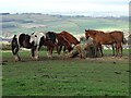
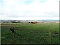
Horses at Medomsley Edge
Group of horses on pasture land on the west side of Medomsley village, beside the path to Fined Road. There is a view behind to the north side of the Derwent Valley at Whittonstall, and beyond into Tynedale.
Image: © Robert Graham
Taken: 18 Nov 2020
0.16 miles