IMAGES TAKEN NEAR TO
East Law, CONSETT, DH8 0QH
Introduction
This page details the photographs taken nearby to East Law, DH8 0QH by members of the Geograph project.
The Geograph project started in 2005 with the aim of publishing, organising and preserving representative images for every square kilometre of Great Britain, Ireland and the Isle of Man.

There are currently over 7.5m images from over14,400 individuals and you can help contribute to the project by visiting https://www.geograph.org.uk
Image Map
Images are licensed for reuse under creativecommons.org/licenses/by-sa/2.0
Notes
- Clicking on the map will re-center to the selected point.
- The higher the marker number, the further away the image location is from the centre of the postcode.
Image Listing (45 Images Found)
Images are licensed for reuse under creativecommons.org/licenses/by-sa/2.0
Image
Details
Distance
1
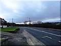
A694 at East Law
Looking south down the main road through the little hamlet of East Law, just south of Ebchester. This is the main Newcastle to Consett road.
Image: © Robert Graham
Taken: 4 Jan 2013
0.02 miles
2
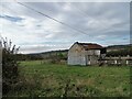
Corrugated iron barn at West Wood Farm
Old barn beside the road at East Law. Probably mid 20th century from the style but looks disused.
Image: © Robert Graham
Taken: 31 Oct 2022
0.04 miles
3
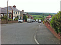
Housing, East Law
A small, well-established development on the steep hillside above Panshield Hags.
Image: © Pauline E
Taken: 31 May 2014
0.05 miles
4
Barns at Westwood Farm, East Law
This farm which seems to specialise in horses, is beside the A694 at East Law, just along the road from Ebchester. There is an earlier farm here also, now in ruins. This can just be made out in the distance between the two barns.
Image: © Robert Graham
Taken: 1 Feb 2017
0.06 miles
5
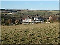
East Law
Houses in the Derwent valley.
Image: © Oliver Dixon
Taken: 16 Dec 2021
0.08 miles
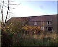
7
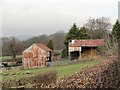
Old farm at East Law
This farm seems to be derelict at the moment, although it was in use recently. It stands beside a little lane between the villages of Ebchester and Shotley Bridge. The houses of the modern estate of East Law can be seen behind.
Image: © Robert Graham
Taken: 3 May 2019
0.09 miles
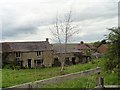
8
Linear farm buildings at East Law
Detail of the old farmstead at East Law. It is a typical early 19th century small farm with the buildings all in a line. The house on the left has attached byres on the right. A simple and very traditional arrangement for farmsteads in this part of the country.
Image: © Robert Graham
Taken: 27 Mar 2023
0.10 miles
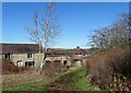
9
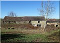
Old farmstead at East Law
This old farmhouse dates back to the early 19th century probably. It's shown on the First Series Ordnance Survey map of 1862. It is a linear type farmstead with a farmhouse and then a byre for the animals attached to it. Obviously it has been altered over the years, but it retains the basic original layout. Doesn't seem to be occupied at present.
Image: © Robert Graham
Taken: 27 Mar 2023
0.10 miles
10
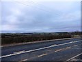
Looking over the valley from East Law
The A694 which runs past this little hamlet is on the valley side above the River Derwent and gives good views to the west over the Northumberland countryside. This side of the river is County Durham however.
Image: © Robert Graham
Taken: 4 Jan 2013
0.12 miles