IMAGES TAKEN NEAR TO
Derwent Dale, CONSETT, DH8 0HZ
Introduction
This page details the photographs taken nearby to Derwent Dale, DH8 0HZ by members of the Geograph project.
The Geograph project started in 2005 with the aim of publishing, organising and preserving representative images for every square kilometre of Great Britain, Ireland and the Isle of Man.

There are currently over 7.5m images from over14,400 individuals and you can help contribute to the project by visiting https://www.geograph.org.uk
Image Map
Images are licensed for reuse under creativecommons.org/licenses/by-sa/2.0
Notes
- Clicking on the map will re-center to the selected point.
- The higher the marker number, the further away the image location is from the centre of the postcode.
Image Listing (89 Images Found)
Images are licensed for reuse under creativecommons.org/licenses/by-sa/2.0
Image
Details
Distance
1
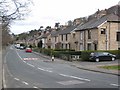
Derwent Dale, Shotley Bridge
The A691 main Consett to Newcastle road.
Image: © Oliver Dixon
Taken: 9 Apr 2007
0.02 miles
2
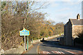
Road sign beside A691 entering Shotley Bridge
The River Derwent which forms the boundary between Northumberland and County Durham lies just over the wall beside the road sign. That blue and yellow sign tells that this side is the Durham side.
Image: © Trevor Littlewood
Taken: 16 Nov 2015
0.06 miles
3
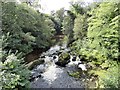
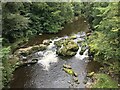
The River Derwent at Shotley Bridge
View upstream from the bridge.
Image: © Robert Graham
Taken: 19 Aug 2019
0.09 miles
4
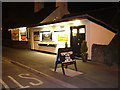
Kings Restaurant Shotley Bridge (At Night)
Image: © Geoff Gill
Taken: 9 May 2006
0.09 miles
5
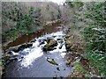
View of the river in winter
Looking up the River Derwent from the bridge at Shotley Bridge.
Image: © Robert Graham
Taken: 13 Dec 2021
0.10 miles
6
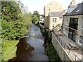
New riverside buildings at Shotley Bridge
View looking downstream along the River Derwent from the bridge. These buildings are on the site of a former flour mill.
Image: © Robert Graham
Taken: 19 Aug 2019
0.11 miles
7
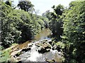
The river Derwent at Shotley Bridge
Looking upriver from the bridge. There are supposed to be holes in the rocks on the river bed which have had millstones cut out of them in past centuries.
Image: © Robert Graham
Taken: 6 Jul 2018
0.11 miles
8
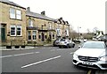
The Crown and Crossed Swords
This hotel in Shotley Bridge village has 18h century origins. However the present appearance dates from an enlargement and alteration of the original Sword Inn in the late 19th, early 20th centuries. The name was changed in 1922.
Image: © Robert Graham
Taken: 13 Dec 2021
0.12 miles
10
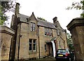
The Vicarage at Shotley Bridge
This is the vicarage for St Cuthberts Church. It's a very fancy vicarage and no surprise to learn that it was designed with the church by the architect John Dobson in 1850.
Image: © Robert Graham
Taken: 1 Sep 2017
0.13 miles