IMAGES TAKEN NEAR TO
Spring Lane, CONSETT, DH8 0EL
Introduction
This page details the photographs taken nearby to Spring Lane, DH8 0EL by members of the Geograph project.
The Geograph project started in 2005 with the aim of publishing, organising and preserving representative images for every square kilometre of Great Britain, Ireland and the Isle of Man.

There are currently over 7.5m images from over14,400 individuals and you can help contribute to the project by visiting https://www.geograph.org.uk
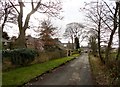
Image Map
Images are licensed for reuse under creativecommons.org/licenses/by-sa/2.0
Notes
- Clicking on the map will re-center to the selected point.
- The higher the marker number, the further away the image location is from the centre of the postcode.
Image Listing (37 Images Found)
Images are licensed for reuse under creativecommons.org/licenses/by-sa/2.0
Image
Details
Distance
3
Old garden walls
Around Snow's Green House at Shotley Bridge. They date back to the C18.
Image: © Robert Graham
Taken: 19 Feb 2017
0.02 miles
4
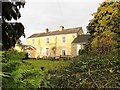
Farmhouse at Snow's Green
Front elevation of the nice old 19th century farmhouse here. Snow's Green was originally a farming hamlet, until Shotley Bridge expanded and absorbed it.
Image: © Robert Graham
Taken: 25 Nov 2019
0.03 miles
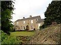
5

Snow's Green house from the west
Large C19 house at the north side of Shotley Bridge.
Image: © Robert Graham
Taken: 19 Feb 2017
0.03 miles
6
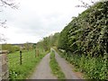
Track to Shotley Park
Old lane leading off West Law Road to the former country house at Shotley Park.
Image: © Robert Graham
Taken: 3 May 2019
0.04 miles
7
Farmhouse at Snow's Green
Probably early C19. This was a small isolated agricultural hamlet but is now part of Shotley Bridge.
Image: © Robert Graham
Taken: 19 Feb 2017
0.04 miles
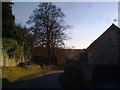
8
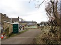
Converted buildings at Snow's Green Farm
There is a modern working farm here, but most of the old C19 buildings have been converted to residential use. That includes the gin gang - the building in the centre here with the segmented roof. This would once have housed a horse engine to drive a threshing machine in the adjacent barn.
Image: © Robert Graham
Taken: 19 Feb 2017
0.04 miles
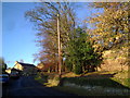
9
Start of West Law Road
This is the south end of the country lane which leads off Snows Green Road here to the former farms at East and West Law.
Image: © Robert Graham
Taken: 1 Sep 2017
0.05 miles
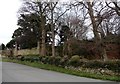
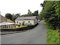
10
Snow's Green from the east
View down West Law Road of this little hamlet, once isolated, but now part of Shotley Bridge.
Image: © Robert Graham
Taken: 19 Feb 2017
0.05 miles