IMAGES TAKEN NEAR TO
Langley Park, DURHAM, DH7 9TR
Introduction
This page details the photographs taken nearby to DH7 9TR by members of the Geograph project.
The Geograph project started in 2005 with the aim of publishing, organising and preserving representative images for every square kilometre of Great Britain, Ireland and the Isle of Man.

There are currently over 7.5m images from over14,400 individuals and you can help contribute to the project by visiting https://www.geograph.org.uk
Image Map
Images are licensed for reuse under creativecommons.org/licenses/by-sa/2.0
Notes
- Clicking on the map will re-center to the selected point.
- The higher the marker number, the further away the image location is from the centre of the postcode.
Image Listing (20 Images Found)
Images are licensed for reuse under creativecommons.org/licenses/by-sa/2.0
Image
Details
Distance
1
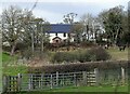
Farmhouse at Stobbilee
The house at Stobbilee Farm on the north side of Langley Park village. The farm predates the village, as it is shown on the first O S map of 1862. The village was only established in the late 19th century by Consett Iron Company as a colliery village.
Image: © Robert Graham
Taken: 21 Feb 2022
0.02 miles
2
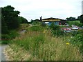
National Cycleway No. 14
Here running alongside a vehicle body repairers inhabiting the old goods yard and cattle dock of Witton Gilbert Station.
Image: © Mick Garratt
Taken: 23 Jul 2005
0.03 miles
3
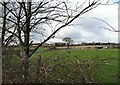
Looking over to Stobbilee Farm
From Front Street, Langley Park. This farm is on the northern side of the village.
Image: © Robert Graham
Taken: 21 Feb 2022
0.05 miles
4
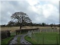
Entrance to farm track
This leads to Stobbilee Farm from Front Street, Langley Park.
Image: © Robert Graham
Taken: 21 Feb 2022
0.10 miles
5
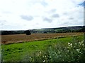
View south from the A691 near Kaysburn
View from beside the Durham to Consett road near Stobbilee House. Looking south over Langley Park to the south side of the Browney valley.
Image: © Robert Graham
Taken: 5 Aug 2015
0.10 miles
6
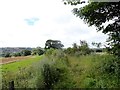
Path to Stobbilee Farm
Footpath leading south from the A691, Durham to Consett road, to Stobbilee Farm at Langley Park.
Image: © Robert Graham
Taken: 5 Aug 2015
0.11 miles
7
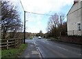
Road into Langley Park village
This is the main road into the village; Front Street. It runs along from the A691, the main road to Durham.
Image: © Robert Graham
Taken: 21 Feb 2022
0.15 miles
8
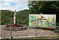
The Wetlands Are Dry
The Wetlands is a sort of park / nature reserve / play area / open space on the edge of Langley Park, with a nice painted poster at the entrance.
Dry as in "No Alcohol Allowed On These Premises" which is what the small red notice says.
Image: © Des Blenkinsopp
Taken: 23 Aug 2022
0.16 miles
9
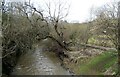
River Browney at Langley Park
View upstream from the bridge on Front Street at the village entrance. The river is swollen from recent rains.
Image: © Robert Graham
Taken: 21 Feb 2022
0.17 miles
10
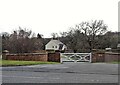
Entrance to Waterford Farm
The entrance gates on Front Street, Langley Park. This is a recent establishment, probably late 20th or 21st century, beside the main road into the village from Durham.
Image: © Robert Graham
Taken: 21 Feb 2022
0.18 miles