IMAGES TAKEN NEAR TO
Bridgeway, DURHAM, DH7 9TQ
Introduction
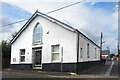
This page details the photographs taken nearby to Bridgeway, DH7 9TQ by members of the Geograph project.
The Geograph project started in 2005 with the aim of publishing, organising and preserving representative images for every square kilometre of Great Britain, Ireland and the Isle of Man.

There are currently over 7.5m images from over14,400 individuals and you can help contribute to the project by visiting https://www.geograph.org.uk
Image Map
Images are licensed for reuse under creativecommons.org/licenses/by-sa/2.0
Notes
- Clicking on the map will re-center to the selected point.
- The higher the marker number, the further away the image location is from the centre of the postcode.
Image Listing (25 Images Found)
Images are licensed for reuse under creativecommons.org/licenses/by-sa/2.0
Image
Details
Distance
1
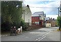
Langley Park
View south from the old railway to Hill Top.
Image: © Mick Garratt
Taken: 23 Jul 2005
0.06 miles
2
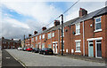
Wood View, Langley Park
One of a number of roads in the area with a paved surface.
Image: © Des Blenkinsopp
Taken: 23 Aug 2022
0.10 miles
3
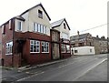
Langley Park Workmens Club
This is on Front Street, as you enter the village from the Durham road.
Image: © Robert Graham
Taken: 21 Feb 2022
0.12 miles
4
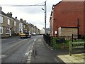
View along Front Street in Langley Park
Looking south down the village main street. This village only dates back to the late 19th century, when The Consett Iron Company opened a colliery here and built houses for its workers.
Image: © Robert Graham
Taken: 21 Feb 2022
0.13 miles
5
Junction of Bridge Street and Front Street, Langley Park
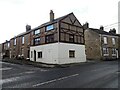
At the east end of the village where the Durham road comes in. Rather unusual building, may have been a shop originally.
Image: © Robert Graham
Taken: 21 Feb 2022
0.13 miles
6
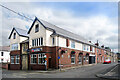
Langley Park Workmen's Club & Institute
The original entrance on Front Street has been bricked up and access is now via a quieter side road.
Image: © Des Blenkinsopp
Taken: 23 Aug 2022
0.13 miles
7
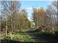
Lanchester Valley Walk
The Lanchester Valley Walk is seen here just east of the old colliery village of Langley Park; the walk follows, as do a number of other routes in County Durham, the course of a dismantled rail route.
Image: © Trevor Littlewood
Taken: 17 Nov 2012
0.13 miles
9
St Joseph's Catholic Church, Hedley Terrace
Image: © Des Blenkinsopp
Taken: 23 Aug 2022
0.14 miles
10
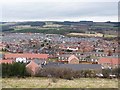
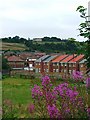
Prospect of Langley Park
Former coal-mining village in the valley of the River Browney; seen from East Clere. The far hilltop is sprouting wind turbines, with the transmitter mast at Burnhope Image to the left.
Image: © Oliver Dixon
Taken: 15 Mar 2013
0.15 miles