IMAGES TAKEN NEAR TO
Quebec, DURHAM, DH7 9RT
Introduction
This page details the photographs taken nearby to DH7 9RT by members of the Geograph project.
The Geograph project started in 2005 with the aim of publishing, organising and preserving representative images for every square kilometre of Great Britain, Ireland and the Isle of Man.

There are currently over 7.5m images from over14,400 individuals and you can help contribute to the project by visiting https://www.geograph.org.uk
Image Map
Images are licensed for reuse under creativecommons.org/licenses/by-sa/2.0
Notes
- Clicking on the map will re-center to the selected point.
- The higher the marker number, the further away the image location is from the centre of the postcode.
Image Listing (24 Images Found)
Images are licensed for reuse under creativecommons.org/licenses/by-sa/2.0
Image
Details
Distance
1
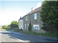
Squarehouse Cottages
Beside the B6301, the Tow Law to Lanchester road.
Image: © Robert Graham
Taken: 15 Aug 2012
0.01 miles
2
Squarehouse Cottages next to the B6301
Image: © Peter Robinson
Taken: 18 Sep 2013
0.02 miles
3
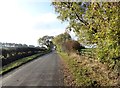
View along Hamsteels Lane
Looking west along this country lane towards its junction with the B6301, which leads north to Lanchester.
Image: © Robert Graham
Taken: 25 Oct 2016
0.03 miles
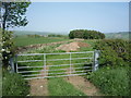
4
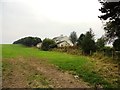
Field south of Square House Farm
The farm beyond the field is, naturally enough, Square House Farm.
Image: © Trevor Littlewood
Taken: 10 Apr 2012
0.12 miles
5
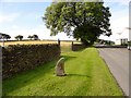
Roadside stone
This stone is at the side of the road leading to Cornsay from the B6301 at Square House farm. This is the farm in the background. Don't know what it's for, looks the wrong shape for a milestone and there is no inscription.
Image: © Robert Graham
Taken: 10 Aug 2016
0.14 miles
6
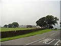
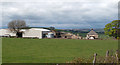
View of Square House farm
Looking from the south, on the B6301.
Image: © Robert Graham
Taken: 15 Aug 2012
0.14 miles
8
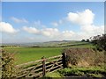
View east from the B6301
From just south of Square House, with a good view over the countryside from up here. The B6301 is the old Roman road of Dere Street. In the distance can be seen the escarpment of Greenland Bank at Esh.
Image: © Robert Graham
Taken: 25 Oct 2016
0.15 miles
9
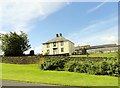
The farmhouse at Square House
This imposing old house sits beside the B6301 south of Lanchester in a prominent position at the top of Bargate Bank. This is the old Roman Dere Street.
Image: © Robert Graham
Taken: 10 Aug 2016
0.15 miles
10
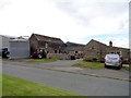
The farmyard at Square House
A view of a nice collection of surviving old farm buildings here, at this farm on the B6301, the old Roman Dere Street. The two storey building at centre left was probably a byer with a hay barn above; a typical early C19 type.
Image: © Robert Graham
Taken: 7 Jul 2015
0.15 miles