IMAGES TAKEN NEAR TO
Esh Winning, DURHAM, DH7 9QD
Introduction
This page details the photographs taken nearby to DH7 9QD by members of the Geograph project.
The Geograph project started in 2005 with the aim of publishing, organising and preserving representative images for every square kilometre of Great Britain, Ireland and the Isle of Man.

There are currently over 7.5m images from over14,400 individuals and you can help contribute to the project by visiting https://www.geograph.org.uk
Image Map
Images are licensed for reuse under creativecommons.org/licenses/by-sa/2.0
Notes
- Clicking on the map will re-center to the selected point.
- The higher the marker number, the further away the image location is from the centre of the postcode.
Image Listing (8 Images Found)
Images are licensed for reuse under creativecommons.org/licenses/by-sa/2.0
Image
Details
Distance
1
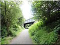
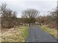
Bridge over the old railway
This is the road into Flass Hall, near Esh Winning. The railway is now the Deerness Valley Walk.
Image: © Robert Graham
Taken: 10 Jul 2013
0.01 miles
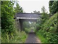
3
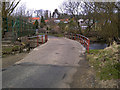
Bridge over the Deerness Valley Railway Path
This path, one of many railway paths in County Durham, follows the line of an old railway from Crook to Durham. The railway was opened in 1858, closed to passengers in 1951 and finally closed in 1964. The bridge carries the road to New Brancepeth, and there is a steep path down from the road to the railway path. Contrast with the summer view at Image
Image: © Oliver Dixon
Taken: 15 Mar 2013
0.20 miles
4
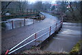
Part-time ford
Part-time ford over the River Deerness below Esh Winning. The debris trapped against the parapet on the upstream side shows that the river was in flood the day previously
Image: © Oliver Dixon
Taken: 3 Apr 2006
0.20 miles
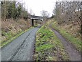
5
Crossing on the Deerness Valley Railway Path
This path, one of many railway paths in County Durham, follows the line of an old railway from Durham to Crook. The railway was opened in 1858, closed to passengers in 1951 and finally closed in 1964. Here it is crossed by the private road leading to Flass Hall.
Image: © Oliver Dixon
Taken: 15 Mar 2013
0.21 miles
6
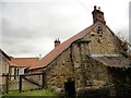
Broadgate Farm
An old farm east of the village of Esh Winning, beside the former Deerness Valley Railway. It is now a used as a day centre for a mental health charity.
Image: © Robert Graham
Taken: 10 Jul 2013
0.21 miles
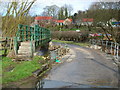
7
Ford at Ushaw Moor
This irish bridge ford is found on the River Deerness at Ushaw Moor, near Esh Winning.
Image: © Gail Cooper
Taken: 9 Apr 2013
0.25 miles
8
Ford at Ushaw Moor
This irish bridge ford is found on the River Deerness at Ushaw Moor.
Image: © John Walton
Taken: 13 Mar 2015
0.25 miles