IMAGES TAKEN NEAR TO
Esh Winning, DURHAM, DH7 9QB
Introduction
This page details the photographs taken nearby to DH7 9QB by members of the Geograph project.
The Geograph project started in 2005 with the aim of publishing, organising and preserving representative images for every square kilometre of Great Britain, Ireland and the Isle of Man.

There are currently over 7.5m images from over14,400 individuals and you can help contribute to the project by visiting https://www.geograph.org.uk
Image Map
Images are licensed for reuse under creativecommons.org/licenses/by-sa/2.0
Notes
- Clicking on the map will re-center to the selected point.
- The higher the marker number, the further away the image location is from the centre of the postcode.
Image Listing (2 Images Found)
Images are licensed for reuse under creativecommons.org/licenses/by-sa/2.0
Image
Details
Distance
1
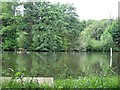
Fishing Pond
Fishing pond and surroundings, between Ushaw farm and Hag House farm.
Image: © Antonia
Taken: 8 Aug 2008
0.19 miles
2
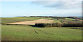
Plantations amid farmland near to Esh
Two plantations are seen in the image; the one right of centre is named Fortypence Plantation, the other is un-named on OS maps.
Image: © Trevor Littlewood
Taken: 10 Dec 2015
0.24 miles