IMAGES TAKEN NEAR TO
Esh Winning, DURHAM, DH7 9HN
Introduction
This page details the photographs taken nearby to DH7 9HN by members of the Geograph project.
The Geograph project started in 2005 with the aim of publishing, organising and preserving representative images for every square kilometre of Great Britain, Ireland and the Isle of Man.

There are currently over 7.5m images from over14,400 individuals and you can help contribute to the project by visiting https://www.geograph.org.uk
Image Map (Loading...)


Getting Data...Please wait
Leaflet Map data © OpenStreetMap
Images are licensed for reuse under creativecommons.org/licenses/by-sa/2.0
Notes
- Clicking on the map will re-center to the selected point.
- The higher the marker number, the further away the image location is from the centre of the postcode.
Image Listing (24 Images Found)
Images are licensed for reuse under creativecommons.org/licenses/by-sa/2.0
Image
Details
Distance
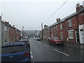
1
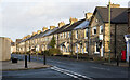
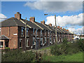
Station View in Esh Winning
Terraced housing on Station View, the B6302, as seen from the Esh Winning village centre outside the Stag's Head.
Image: © Trevor Littlewood
Taken: 20 Dec 2022
0.04 miles
2
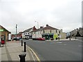
Road junction at Esh Winning village centre
View from the west of the junction between Newhouse Road , on the left, and Durham Road, on the right. This is the village centre with all the shops etc.
Image: © Robert Graham
Taken: 10 Jul 2013
0.05 miles
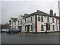
3
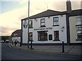
Stags Head Hotel, Esh Winning
At the junction of Newhouse Road and Station View; a dogleg bend in the B6302.
Image: © Stanley Howe
Taken: 21 Sep 2013
0.05 miles
4
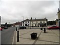
Centre of Esh Winning
Looking SW from Durham Road down Station View. Esh Winning is a large ex mining village west of Durham City, and was founded in the 1850s to service the new colliery here. It takes its name from the old village of Esh on the valley top a couple of kilometres away to the north.
Image: © Robert Graham
Taken: 10 Jul 2013
0.06 miles
5
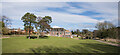
Esh Winning Methodist Church
The Esh Winning Methodist Church seen across an expanse of grass, just above the Deerness Valley Railway Walk, which is just visible at the right side of the image above tree shadows.
Image: © Trevor Littlewood
Taken: 12 Mar 2021
0.06 miles
8
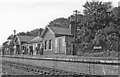
Waterhouses (closed) station,1958
View SW, towards Brancepeth Colliery for mineral traffic. Until closed 29/10/51 it was the terminus of the Dearness Valley branch from Durham of a passenger service of one train a day - also for a service on Durham Miners' Gala Day, once a year until 7/60. Goods trains ran to Brancepeth until 10/8/64, to Waterhouses until 28/12/64. The photograph was taken on the occasion of a Rail Tour.
Image: © Walter Dendy, deceased
Taken: 31 Aug 1958
0.09 miles
9
Station View, Esh Winning
Esh Winning is a former colliery village of County Durham.
Appropriately, the terraced housing of Station View looks out towards the Deerness Valley Railway Walk, from where the image was recorded.
Image: © Trevor Littlewood
Taken: 6 Oct 2012
0.09 miles
10
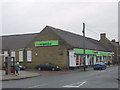
The Co-operative store in Esh Winning
Image: © Peter Robinson
Taken: 9 Feb 2011
0.10 miles