IMAGES TAKEN NEAR TO
Beechcroft Avenue, DURHAM, DH7 8TF
Introduction
This page details the photographs taken nearby to Beechcroft Avenue, DH7 8TF by members of the Geograph project.
The Geograph project started in 2005 with the aim of publishing, organising and preserving representative images for every square kilometre of Great Britain, Ireland and the Isle of Man.

There are currently over 7.5m images from over14,400 individuals and you can help contribute to the project by visiting https://www.geograph.org.uk
Image Map
Images are licensed for reuse under creativecommons.org/licenses/by-sa/2.0
Notes
- Clicking on the map will re-center to the selected point.
- The higher the marker number, the further away the image location is from the centre of the postcode.
Image Listing (4 Images Found)
Images are licensed for reuse under creativecommons.org/licenses/by-sa/2.0
Image
Details
Distance
1
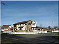
Forest View, Brandon
Modern housing on the edge of a former coal-mining village
Image: © Oliver Dixon
Taken: 17 Feb 2006
0.10 miles
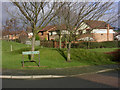
2
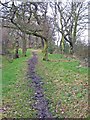
Scripton Gill
This pleasant path runs along a narrow strip of woodland beside the stream from Brandon up to Pithouse Plantation.
Image: © Oliver Dixon
Taken: 23 Feb 2007
0.15 miles
3
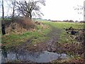
Field beside Scripton Gill
Housing on the edge of Brandon can be seen in the distance.
Image: © Oliver Dixon
Taken: 23 Feb 2007
0.16 miles