IMAGES TAKEN NEAR TO
Boyne Court, DURHAM, DH7 8LS
Introduction
This page details the photographs taken nearby to Boyne Court, DH7 8LS by members of the Geograph project.
The Geograph project started in 2005 with the aim of publishing, organising and preserving representative images for every square kilometre of Great Britain, Ireland and the Isle of Man.

There are currently over 7.5m images from over14,400 individuals and you can help contribute to the project by visiting https://www.geograph.org.uk
Image Map
Images are licensed for reuse under creativecommons.org/licenses/by-sa/2.0
Notes
- Clicking on the map will re-center to the selected point.
- The higher the marker number, the further away the image location is from the centre of the postcode.
Image Listing (7 Images Found)
Images are licensed for reuse under creativecommons.org/licenses/by-sa/2.0
Image
Details
Distance
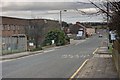
1
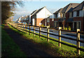
Wooden fencing alongside Brandon - Bishop Auckland Railway Path
The Brandon to Bishop Auckland Railway Path is separated by the fence from a newly constructed road with newly built houses. Neither the road nor the houses are marked currently (December 2014) on OS maps.
Image: © Trevor Littlewood
Taken: 30 Nov 2014
0.12 miles
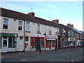
2
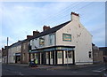
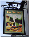
The Station Inn, Langley Moor
On High Street South.
Image: © JThomas
Taken: 6 Dec 2015
0.17 miles
7
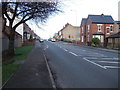
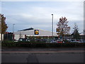
High Street (A690), Meadowfield
Looking north east.
Image: © JThomas
Taken: 6 Dec 2015
0.25 miles