IMAGES TAKEN NEAR TO
Swale Court, DURHAM, DH7 8JL
Introduction
This page details the photographs taken nearby to Swale Court, DH7 8JL by members of the Geograph project.
The Geograph project started in 2005 with the aim of publishing, organising and preserving representative images for every square kilometre of Great Britain, Ireland and the Isle of Man.

There are currently over 7.5m images from over14,400 individuals and you can help contribute to the project by visiting https://www.geograph.org.uk
Image Map
Images are licensed for reuse under creativecommons.org/licenses/by-sa/2.0
Notes
- Clicking on the map will re-center to the selected point.
- The higher the marker number, the further away the image location is from the centre of the postcode.
Image Listing (17 Images Found)
Images are licensed for reuse under creativecommons.org/licenses/by-sa/2.0
Image
Details
Distance
1
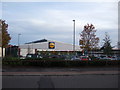
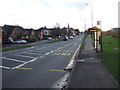
High Street (A690), Meadowfield
Looking north east.
Image: © JThomas
Taken: 6 Dec 2015
0.07 miles
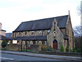
2
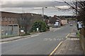
St Patricks RC Church
Sited at Goat's Bridge. Which no longer exists, the stream having been culverted.
Image: © Mick Garratt
Taken: 1 Feb 2014
0.08 miles
4
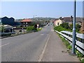
Bus stop and shelter on High Street (A690), Meadowfield
Image: © JThomas
Taken: 6 Dec 2015
0.09 miles
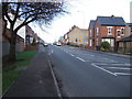
6
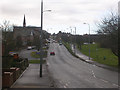
Lobley Hill Road, between Langley Moor and Meadowfield
There is a very narrow green belt (on the right hand side of the picture) between the former mining villages of Langley Moor and Meadowfield. The road in the picture is the A690 between Durham and Willington.
Image: © Oliver Dixon
Taken: 17 Feb 2006
0.16 miles
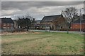
9
Crossroads: Mill Road, Onslow Terrace, Littleburn Road
Image: © Roger Smith
Taken: 7 May 2008
0.20 miles