IMAGES TAKEN NEAR TO
Browney, DURHAM, DH7 8HY
Introduction
This page details the photographs taken nearby to DH7 8HY by members of the Geograph project.
The Geograph project started in 2005 with the aim of publishing, organising and preserving representative images for every square kilometre of Great Britain, Ireland and the Isle of Man.

There are currently over 7.5m images from over14,400 individuals and you can help contribute to the project by visiting https://www.geograph.org.uk
Image Map
Images are licensed for reuse under creativecommons.org/licenses/by-sa/2.0
Notes
- Clicking on the map will re-center to the selected point.
- The higher the marker number, the further away the image location is from the centre of the postcode.
Image Listing (18 Images Found)
Images are licensed for reuse under creativecommons.org/licenses/by-sa/2.0
Image
Details
Distance
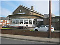
1
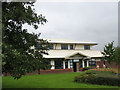
Harrison and Harrison
This unassuming building in a business park is the new home of the historic organ builders Harrison & Harrison.
Image: © Stephen Craven
Taken: 22 Sep 2008
0.03 miles
2
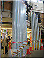
New organ pipes
A rank of new organ pipes awaits delivery from the factory Image
Image: © Stephen Craven
Taken: 22 Sep 2008
0.04 miles
3
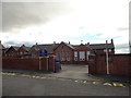
Browney Primary School, Meadowfield
Old school at Meadowfield, Brandon. Looks Edwardian possibly.
Image: © Robert Graham
Taken: 24 Jul 2012
0.11 miles
5
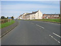
Entering Browney from the south east
Image: © Peter Robinson
Taken: 23 Sep 2012
0.17 miles
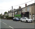
6
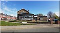
Meadowfield and District Social Club and Institute
Image: © Anthony Parkes
Taken: 22 Apr 2022
0.20 miles
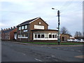
7
Meadowfield and District Social Club and Institute
Image: © Peter Robinson
Taken: 23 Sep 2012
0.20 miles
8
Meadowfield & District Social Club & Institute
Image: © JThomas
Taken: 6 Dec 2015
0.20 miles
9
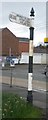
Old Direction Sign - Signpost by the B6300, Brandon and Byshottles parish
Cone finial - 1 arm; by the B6300, in parish of Brandon and Byshottles (Durham District), Southwest corner of the junction of the A690 and the B6300 in Meadowfield.
Surveyed
Milestone Society National ID: DU_NZ2439
Image: © Milestone Society
Taken: Unknown
0.22 miles
10
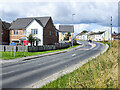
Detached house beside Browney Lane
The road is Browney Lane, the B6300. The detached house is one of a number of recently built properties just outside the village of Meadowfield. At the left side of the image is a road sign in the blue and yellow colours found typically in County Durham.
Image: © Trevor Littlewood
Taken: 16 Aug 2021
0.22 miles