IMAGES TAKEN NEAR TO
Grove Road, DURHAM, DH7 8AR
Introduction
This page details the photographs taken nearby to Grove Road, DH7 8AR by members of the Geograph project.
The Geograph project started in 2005 with the aim of publishing, organising and preserving representative images for every square kilometre of Great Britain, Ireland and the Isle of Man.

There are currently over 7.5m images from over14,400 individuals and you can help contribute to the project by visiting https://www.geograph.org.uk
Image Map
Images are licensed for reuse under creativecommons.org/licenses/by-sa/2.0
Notes
- Clicking on the map will re-center to the selected point.
- The higher the marker number, the further away the image location is from the centre of the postcode.
Image Listing (9 Images Found)
Images are licensed for reuse under creativecommons.org/licenses/by-sa/2.0
Image
Details
Distance
1
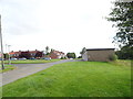
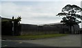
Housing estate at Brandon
Housing estate at the south end of the village, neaxt to the old railway.
Image: © Robert Graham
Taken: 24 Jul 2012
0.12 miles
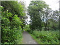
2
Route of the former Bishop Auckland - Durham railway at Brandon
Image: © David Robinson
Taken: 15 Feb 2023
0.15 miles
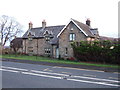
3
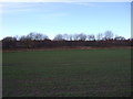
Young crop field near Brandon
Looking towards the former Bishop Auckland to Brandon Railway.
Image: © JThomas
Taken: 6 Dec 2015
0.18 miles
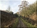
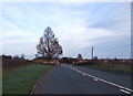
4
Old railway walk at Brandon
Looking west along the Brandon to Bishop Auckland Walk.
Image: © Robert Graham
Taken: 24 Jul 2012
0.18 miles
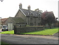
9

Entering Meadowfield
Heading north east on the A690.
Image: © JThomas
Taken: 6 Dec 2015
0.24 miles