IMAGES TAKEN NEAR TO
Durham Court, DURHAM, DH7 6UZ
Introduction
This page details the photographs taken nearby to Durham Court, DH7 6UZ by members of the Geograph project.
The Geograph project started in 2005 with the aim of publishing, organising and preserving representative images for every square kilometre of Great Britain, Ireland and the Isle of Man.

There are currently over 7.5m images from over14,400 individuals and you can help contribute to the project by visiting https://www.geograph.org.uk
Image Map
Images are licensed for reuse under creativecommons.org/licenses/by-sa/2.0
Notes
- Clicking on the map will re-center to the selected point.
- The higher the marker number, the further away the image location is from the centre of the postcode.
Image Listing (5 Images Found)
Images are licensed for reuse under creativecommons.org/licenses/by-sa/2.0
Image
Details
Distance
1
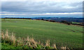
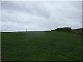
Field south of Sacriston
The view is to the east over a field with an emerging crop from Bowbank, a road in a development known as Southburn Rise at the southern side Sacriston.
Image: © Trevor Littlewood
Taken: 16 Dec 2015
0.10 miles