IMAGES TAKEN NEAR TO
Kaysburn, DURHAM, DH7 6TL
Introduction
This page details the photographs taken nearby to Kaysburn, DH7 6TL by members of the Geograph project.
The Geograph project started in 2005 with the aim of publishing, organising and preserving representative images for every square kilometre of Great Britain, Ireland and the Isle of Man.

There are currently over 7.5m images from over14,400 individuals and you can help contribute to the project by visiting https://www.geograph.org.uk
Image Map
Images are licensed for reuse under creativecommons.org/licenses/by-sa/2.0
Notes
- Clicking on the map will re-center to the selected point.
- The higher the marker number, the further away the image location is from the centre of the postcode.
Image Listing (12 Images Found)
Images are licensed for reuse under creativecommons.org/licenses/by-sa/2.0
Image
Details
Distance

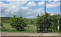
4
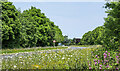
Wild flowers alongside Low Moor Road
For several years Durham County Council has grown wild flowers at various locations - roadside verges and roundabouts for example - for environmental benefit, visual attraction and no doubt, for lower maintenance costs. Those in the image line both sides of a stretch of Low Moor Road north-east of Langley Park.
Image: © Trevor Littlewood
Taken: 11 Jun 2023
0.12 miles
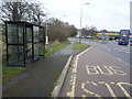
6
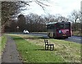
X20 leaving Langley Park
This is the Go North East service to Sunderland via Durham city. The road from the village here leads to the A691 into Durham.
Image: © Robert Graham
Taken: 21 Feb 2022
0.14 miles
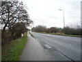
7
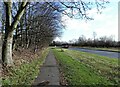
Road leading from Langley Park
The main access road into the village, which leads onto the A691, the road to Durham.
Image: © Robert Graham
Taken: 21 Feb 2022
0.16 miles
8
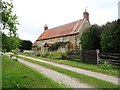
Kaysburn House
This attractive old house is just off the A691 beside the Kaysburn roundabout. It lies between the villages of Langley Park and Witton Gilbert.
Image: © Robert Graham
Taken: 10 Jul 2013
0.16 miles
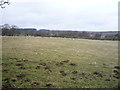
10
Farmland west of Witton Gilbert
Land rising towards Charlaw Fell.
Image: © Pauline E
Taken: 1 Jun 2013
0.20 miles